GPS UNITS CAN SHOW YOU THE WAY
Published 12:00 am Friday, May 31, 2002
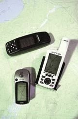
- NUMEROUS MODELS AVAILABLE: A GPS unit works by receiving signals from the satellites overhead, usually capturing six of the signals in open terrain, and sometimes more. It then performs a series of mathematical calculations based on the positions of the satellites and the amount of time it takes the signals from the different satellites to reach the GPS unit.After completing the number crunching, the unit displays two coordinates that can be located on a map. Different maps use different numeric systems, so a GPS unit user must make sure the GPS unit and map are using the same numeric system. (Bend Bulletin/Rob Kerr).
By Keith Ridler
For The Observer
For outdoor adventurers, the $100,000 question has always been: "Where are we?"
These days, technology has reduced the cost to just north of $100 with Global Positioning System units.
"They are incredible bargains," says Bob Speik, a Bend area mountaineer and backcountry adventurer who teaches GPS classes. "They are incredible technology at an amazingly low price."
Many trail books, mountain bike books, and others use GPS way points to mark significant locations, like turns in the trail. A GPS user can also store his or her own way points in the GPS for use at a later time, such as the location of the vehicle or the route for returning to that secret, hard-to-find fishing spot next month.
A GPS unit can also determine the elevation at a particular point, download computer software with maps, and be programmed to mark the way before the user heads into the backcountry.
For all the tasks they are asked to perform, the hand-held GPS units seem ridiculously small and lightweight until you realize they are backed up by a network of 24 satellites (12 in each hemisphere at any one time) orbiting about 12,000 miles above the earth.
Twenty-four is the most commonly cited number of satellites, though there are apparently spares also orbiting the planet.
"There may be 34 or 64 up there. We don’t know," says Speik. "It is a defense-based navigation system."
The satellite network was designed and built by the United States to help fighting forces pinpoint their own locations, as well as the enemy’s, and so there is a degree of secrecy and some contradictory information about some of the details of the system.
However, the system was made available for public use in the mid 1990s, but with "selective availability" that purposefully gave inaccurate information to privately-owned GPS units, misdirecting them by introducing a wandering error of up to 600 feet. The idea was to prevent someone with evil intent from using the GPS system as a targeting device.
But on May 1, 2000, that purposeful misdirection was eliminated, so that private GPS users can expect amazing accuracy to within a few meters. Military uses remain more accurate, to within inches. But for private GPS users who aren’t concerned, for example, about directing a cruise missile into the mouth of a small cave opening, the accuracy is astounding.
Speik has even experimented atop Pilot Butte, testing the accuracy of his Garmin Etrex GPS on some 25 different occasions. The GPS has every time been within six feet of elevation and 15 feet laterally, Speik notes, comparing the GPS readings to the United States Geological Survey marker on the butte.
"That’s mind-boggling accuracy," says Speik. "And the GPS doesn’t know it’s on Pilot Butte. That’s anywhere in the world. It’s that accurate any where in the world."
The Garmin Etrex is the least-expensive GPS on the market, usually costing about $120. The more bells and whistles, the more pricey a GPS becomes, with some costing more than $500.
But what all recent GPS units have in common is the way in which they pinpoint locations. That means recent GPS units are equally accurate, no matter the cost. That’s not to say some extra features that cost more might not be useful, but they provide better precision.
"I’ve got seven different models," says Art McEldowney, a former telecommunications officer with the U.S. Department of State and a backcountry enthusiast who also offers GPS classes. "They all have the same degree of accuracy. So if you spend $109 on one or $509 on one, you get the same degree of accuracy."
"People think you get more accuracy if you pay more," says Speik. "That’s not true. All a GPS is is a radio receiver, a little CPU, a quartz clock and a little dedicated software."
A GPS unit works by receiving signals from the satellites overhead, usually capturing six of the signals in open terrain, and sometimes more. It then performs a series of mathematical calculations based on the positions of the satellites and the amount of time it takes the signals from the different satellites to reach the GPS unit.
After completing the number crunching, the unit displays two coordinates that can be located on a map. Different maps use different numeric systems, so a GPS unit user must make sure the GPS unit and map are using the same numeric system.
Many maps use the Universal Transverse Mercator (UTM) grid. After the GPS unit displays the UTM numbers, those numbers are found along the edges of the map. The point on the map where the numbers intersect is where the GPS unit is located.
"It gives you numeric coordinates, which is the same as saying Highway 20 and 27th Street," notes Speik.
Another handy function of a GPS unit is the go-to mode. A hiker who wants to return to his or her vehicle which has been marked with a way point can hit the go-to function of the GPS unit. The unit will display the direction and distance to the vehicle. The user can then use the compass and map to go to the vehicle.
GPS units can even be downloaded with USGS quad maps, and the unit will display a map showing the terrain between the current location and the vehicle.
"Mine has two-thirds of the state of Oregon loaded into it," says McEldowney.
Also available are GPS units that display sunrise, sunset, moonrise, moonset, moon phase, the best times for hunting and fishing, electronic compasses, and more.
Before getting carried away with the abilities of a GPS unit, both Speik and McEldowney point out that such a device is simply another back country tool along with a map and compass. A GPS unit with dead batteries, or one at the bottom of the river, won’t be much help.
"I’m not aware of any GPS manufacturer that will stand behind their product as a primary source of navigation," says McEldowney. "It should be used as an augmentation tool."
GPS units have become so inexpensive and popular that recently they have led to a new sport called geocaching. A Web site (geocaching.com) lists hints and coordinates for locations of cached or hidden items. A person with a GPS unit can go out and try to find the items, or create and hide a cache and list it on the Web site.
Caches typically consist of inexpensive items. A finder of a cache can take some items from it but is expected to leave something behind as well.