MEASURED APPROACH
Published 12:00 am Monday, February 2, 2004
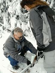
- WEIGHING IN: Mike Burton of the Natural Resources Conservation Service office in Island City carefully places the snow tube in the cradle of the weigh scale held by Lisa Krieger of the Bureau of Reclamation during a snowpack surveyconducted Jan. 27. (The Observer/MARDI FORD).
By Mardi Ford
Trending
Observer Staff Writer
The sound of snowshoes crunching through the pristine white surface is all that can be heard. Two grey-clad figures make their way through tall timber uphill to the snow course.
"See that marker?" Mike Burton points to a metal shield attached to a pole driven deep in the snow.
Trending
"This is where we’ll take the first measurement," he says. "Down the hill," he turns and gestures widely, "is another one, but you probably can’t see it."
Following his gesture down the hill, the snow course is wide and cleared of timber to capture the snow. It slopes as gently as a beginner’s ski run. The view of the pastel valley in the distance is spectacular.
Today Burton, who is with the Natural Resources Conservation Service in Island City, and Lisa Krieger of the Bureau of Reclamation in Pendleton, will measure this slope at five designated points between the markers.
They are taking two measurements one for snow depth and one for weight. They use a deceptively simple looking instrument called a snow tube. Simple, but expensive.
"Yeah, it costs a whole bunch to make one of these," Burton said earlier, as he carefully unrolled a canvas and removed the 10-foot snow tube in sections to screw together.
"But this," he holds up a rusty, old table knife, "is probably the most important tool we use." Krieger grins and agrees.
Equipped with the snow tube, the table knife, a weighing scale and cradle, field data notebook and pencil, the pair start off the road and head into the trees making for the snow course.
"We try to keep off the snow course as much as possible," Burton cautions. "Stay in my tracks and keep to the side."
At the first measuring point, Krieger makes a right angle into the middle of the site and drives the snow tube deep into the white.
"Thirty-one point five," she calls back to Burton who is waiting at the edge of the course. He writes the figure in his notebook while Krieger retraces her steps back to the edge.
Working carefully and quickly, the pair weigh the snow-filled tube. It is the density of the core sample they are interested in, not the depth of the snow pack.
"I don’t really care about how deep it is," Burton jokes, "unless it gets over the top of my shoes."
They calculate the core sample’s water content by dividing the weight of the snow by the depth of the snow, adjusting for the weight of an empty tube. That percentage, based upon the depth, yields water content.
What both agencies are measuring for today will determine how many inches of actual water is held within the snow, or the snow water equivalent.
According to Burton, the SWE is the amount of actual water that would theoretically result if the entire snowpack melted instantaneously. Fresh powder would leave very little water behind where a dense, wet snow would obviously leave more.
The snow course sites are surveyed monthly throughout the season, which runs from January to April. Historically, this is the method by which snowpack has been surveyed since the turn of the century, Burton says.
"In the early days, they used to drop a layer of colored sand before the snowfall," he tells. "Then they knew they’d hit ground by the colored sand in the bottom of the core sample. They had to sample the exact location every time, looking for the colored sand."
There are two other methods the NRCS uses to survey snowpack. One is the automated system of the Snotel sites developed in the 1960s which measure and broadcast data to a central location in Fort Collins, Colo.
"Each site is equipped with a snow pillow filled with antifreeze," Burton says.
The pillow measures weight and content with precipitation gauges, depth sensors and all kinds of high tech equipment that transmit the results through meteor bursts that bounce off atmospheric debris. The system is unique to the West, with Alaska, Arizona, California, Colorado, Idaho, Montana, Nevada, New Mexico, Oregon, Utah, Washington, and Wyoming participating.
The third method for snowpack survey uses aerial markers that were developed in the 1950s, Burton says. These are actually long ladders attached to the mountain with horizontal markers set along the length at every 24 inches.
Burton and a pilot do a fly-by of six sites in the Wallowa Mountains in a helicopter in January and March with a representative with the NRCS in Baker City.
Burton bends over to adjust an uncooperative snowshoe that continues to work loose in the heavy snow.
"I hope we’re seeing the end of the drought cycle," Burton says.
Being in a drought cycle will affect spring runoff, he says. If the soil is very dry at the beginning of the season, it will absorb a lot of moisture when the snowpack begins to thaw. But he remains cautiously optimistic with the current levels of precipitation approaching normal for this area.
He takes the table knife hanging on a cord around his neck and scoops the bottom layer of dirt and rocks out of the end of the snow tube which would affect the weight of the core sample and skew the SWE calculation. Carefully, he places the tube in the cradle of the weighing scale hanging from a cord around Krieger’s neck.
The two grey-clad figures, their heads bent together, focus on the task at hand.


-
eEdition

-

-
