Wildlife viewing just got easier
Published 8:15 pm Friday, September 23, 2011
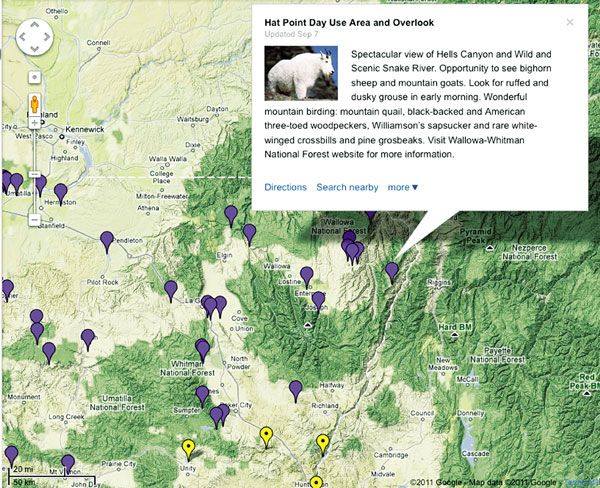
- This new ODFW wildlife viewing site tool is linked with Google Maps. A descriptive bubble for each site provides information about the specific species of wildlife people can see.
ODFW Wildlife Viewing Map makes it simpler for Oregonians to answer the question, ‘Where can I go to see wildlife?’
Finding wildlife viewing sites in Northeast Oregon and throughout the state is now easier than taking a stroll on the Ladd Marsh Nature Trail.
A new online feature available from the Oregon Department of Fish and Wildlife is why. The ODFW Wildlife Viewing Map went on line last week. The map is making it simpler for Oregonians to answer the question, “Where can I go to see wildlife?”
To date thousands of people have already turned to it for answers.
The ODFW Wildlife Viewing Map has had more than 14,000 hits since it went online Sept. 14.
“People seem to be excited about it and are forwarding the link to it to their friends,” said Meg Kenagy, head of the wildlife viewing map project and the ODFW’s conservation communications coordinator.
The new map is meant to serve as a tool for people looking for places to view specific types of wildlife.
It contains information on 235 wildlife viewing sites, directions to the sites, satellite images of them and much more. The map also provides links to websites providing additional information on the wildlife viewing sites.
The online map is meant to provide information that everyone from people new to the state to outdoor enthusiasts who have lived in Oregon for decades will find informative
Map viewers will learn that in Baker County’s Burnt River Canyon visitors can see bighorn sheep between November and April. They also will be advised to “…listen for butting heads of (bighorn sheep) during the fall rut.”
The map is one of the few anywhere with information finding bats. Scroll to the Milo McIver State Park site to find it.
Map viewers will find information about a bat trail at the park, about 40 miles from Portland on the Clackamas River. The focal point of the trail is a barn that is a nursery colony for Townsend’s big-earred bats. It has only adult female bats and their young. The nursery colony is one of the few for Townsend’s big-earred bats known to exist in Oregon.
The online ODFW map includes a photo of the “bat” barn and some of the eight bat houses on the trail, which were made by Boy Scouts in 2002.
The bat trail and all of the places featured on the map are on public land that is open to everyone.
Milo McIver is one of many state parks on the ODFW map. Also shown are city and county parks, Crater Lake National Park, fish hatcheries, wildlife refuges, reservoirs, lakes, wildlife areas, wilderness areas and more. All were included based on the recommendations of ODFW biologists
Northeast Oregon wildlife viewing sites listed in addition to Burnt River Canyon include the Elkhorn Wildlife Area, the Elkhorn Wildlife Area’s Anthony Creek viewing site; the Hat Point day use area and overlook; the Ladd Marsh Wildlife Area’s nature trail, Foothill Road viewpoint and Tule Lake access area; Lookingglass Hatchery, the Wallowa Hatchery, the Weneha Wildlife Area, the Zumwalt Prairie Preserve Horned Lark Trail and the Zumwalt Prairie Preserve Biscuit Vista Trail.
The satellite images of the 235 wildlife viewing sites on the map are linked to Google Maps. Users will get overviews of exactly what they will see when they enter a site via a zoom function. The zoom function takes users to a trailhead, a parking lot or a viewpoint.
“We didn’t want someone to zoom into the middle of a forest,” Kenagy said.
A two-minute video tutorial is at the site of the online map to help those who are not familiar with how to use Google Maps and their satellite images.
People of all physical ability levels will find places on the map to meet their needs. Sites range from overlooks with platforms people can drive up to and short trails with no barriers to difficult steep trails for aggressive hikers.
Kenagy started on the map project in 2009. She was inspired to take it on in part because she wants people to appreciate the breadth of the ODFW’s expertise in terms of wildlife.
“A lot of people do not realize that the ODFW manages almost all wildlife, not just hunted species and fish,” Kenagy said.
She also wanted to help get more people interested in wildlife. Good things happen when this occurs.
“When people become engaged with wildlife they begin to understand the importance of conservation and habitat,” Kenagy said.
The map is available on the ODFW’s website, www.dfw.state.or.us.