Nordic skiers can find ample snow at Salt Creek Summit
Published 11:26 pm Thursday, February 9, 2012
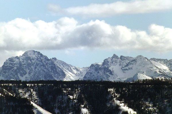
- Idahos Seven Devils range is visible from many of the cross country ski trails accessed from the Sno-Park at Salt Creek Summit southeast of Joseph. KATY NESBITT / The Observer
Snow has largely eluded the Wallowa Valley this winter, but don’t be fooled – there’s plenty of the white stuff available at Salt Creek Summit for a variety of cross country ski tours.
A map of seven cross country ski trails and their descriptions is for sale at the Wallowa County Chamber of Commerce in Enterprise. The map labels the trails as “Easiest,” “More Difficult” and “Most Difficult.”
The Summit Loop, accessible from the Salt Creek Summit parking lot and totaling 1.3 miles, is a flat, easy half hour ski loop suited for beginners. The loop has several gentle hills and passes through open meadows and timber.
The Divide Loop is designated More Difficult and is a 1.7-mile extension of the Summit Loop. It takes between one and one and a half hours to ski from the Salt Creek Summit parking lot.
Skiing the loop clockwise is recommended to enjoy a steep descent on the west side, just north of the junction with the Summit Loop. There is a gradual ascent on the north end of the loop, and the remainder is on a flat ridge top.
The Mountain View Loop, a More Difficult trail, is 2.9 miles and accessed from the east end of the Divide Loop. It takes three to four hours to ski from the parking lot.
This trail has several steep hills on the north and west sides of the loop and may be skied in either direction. The east half is a gently sloping ridge top through open meadows with views of Wing Ridge and the Eagle Caps.
Devils Loop, a More Difficult trail that is 1.8 miles, takes about an hour and a half to ski with excellent views of Idaho’s Seven Devils mountain range. There is a short but steep pitch at the southern junction with the Wagon Road Trial. A short cutoff trail may be used to add variety.
The Redmont Trail is 7.9 miles and is a combination of roads and trails. It passes through a variety of terrain. Many moderately steep hills are encountered while skiing either direction. Skiers planning a tour of the entire length should consider a vehicle shuttle and allow five to six hours.
Wagon Road Trail is More Difficult and 4.1 miles. One and a half to two hours should be allowed to ski one way to the junction of the Big Sheep Cutoff Trail. The Wagon Road winds along the lower slopes of Wing Ridge with several gradual ascents.
Big Sheep Cutoff is labeled Most Difficult, but is only a half mile of challenging switchbacks negotiating 200 feet of elevation. The trail goes to the Wagon Road and crosses three bridges over Big Sheep Creek then climbs to a Wing Ridge Ski Tours shelter. Allow a half hour to climb back up to Wagon Road Trail. Climbing skins or wax are appropriate.
A permit is necessary to access trails from either the McCully Creek or Salt Creek Summit sno-parks between Nov. 15 and April 30. Permits can be purchased at the DMV or Outlaw Motor Sports in Enterprise or at the Sports Corral or Joseph Hardware in Joseph.
Maps are $2 and available at the Wallowa County Chamber of Commerce, 309 S. River St. in Enterprise.