A dubious distinction
Published 10:52 am Monday, February 18, 2013
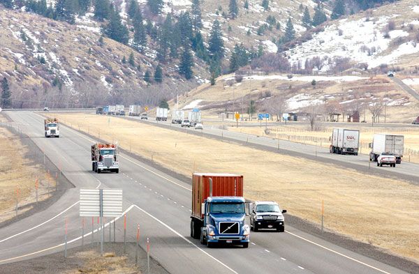
- The section of Interstate 84 known for inclement weather is the 165 miles through the Blue Mountains between Pendleton, in the Columbia River Basin, and Ontario, beside the Snake River on the Oregon-Idaho border. This part of I-84, which roughly parallels the route of the historic Oregon Trail, passes through La Grande and Baker City, the two largest cities between Pendleton and Ontario. CHRIS BAXTER/The Observer
by JASON JACOBY / WesCom News Service
Several factors earn region’s Interstate 84 a widespread reputation for difficult driving conditions
The best way to get around in Oregon’s northeast corner is on a route that’s prone to some of the region’s worst weather.
This paradox of Interstate 84 has earned the four-lane freeway – the most direct route between Portland, Boise and Salt Lake City – a widespread reputation for difficult driving conditions.
The section most notorious for inclement weather is the 165 miles through the Blue Mountains between Pendleton, in the Columbia River Basin, and Ontario, beside the Snake River on the Oregon-Idaho border.
This part of I-84, which roughly parallels the route of the historic Oregon Trail, passes La Grande and Baker City, the two largest cities between Pendleton and Ontario.
It also includes perhaps the most misleadingly named place in the whole region, said Rachelle Lemmon, who drives buses for the Baker School District.
That’s Pleasant Valley.
The area, about eight miles south of Baker City, has neither steep grades nor sharp curves.
But its microclimate makes it prone to snow and, especially, ice, when the freeway on either side is clear.
“There’s nothing pleasant about it, at least during the winter,” Lemmon said.
Interstate 84, in addition to its importance for local residents, is a vital commercial pike, with trucks making up about 43 percent of the traffic, a much higher percentage than for other sections of interstate highway in Oregon.
It’s also one of the more scenic pieces of interstate in Oregon, passing through the pine and fir forests of the Blue Mountains. The area’s recreational opportunities, which include hunting, fishing and the nearby Eagle Cap Wilderness, Oregon’s largest backcountry area, attract visitors from across the nation.
And many of those drivers live in places where gentle
terrainand temperate weather predominate.
“There are a lot of people from out of state who don’t know what these mountains are about,” said Wendee Morrissey, who has driven buses for the Baker School District for 27 years. “We only do 55 mph. People see that big yellow bus and think they just have to get around that.”
The route through the Blues is infamous not only for its weather but also for its topography, which posed some of the more daunting challenges for 19th century pioneers in the ox-drawn covered wagons.
In contrast to the generally flat terrain which the freeway, and the Oregon Trail before it, traverses in the 200 miles between Portland and Pendleton, the section through the Blues includes:
andbull; Four grades of 5 percent or 6 percent, among them Cabbage Hill just east of Pendleton, where the westbound lanes plunge almost 3,000 vertical feet from the mountains into the Columbia Basin in a series of corners.
This is one of a handful of highways in Oregon where the Oregon Department of Transportation (ODOT) built emergency “escape ramps” – uphill lanes carved into the slope beside the highway where truck drivers can stop if their brakes fail on the five-mile descent.
The heaviest commercial trucks are urged, by a series of signs, not to exceed about 18 mph, lest their brakes overheat.
In summertime, ODOT fills 50-gallon metal barrels with water for drivers to use to refill radiators that have boiled over on the eastbound ascent.
“You always have to be prepared for those steep hills,” said Sandy Fuller, who commutes two or three times per week from her home in Weiser, Idaho, to Marvin Wood Products in Baker City, a 65-mile route that includes about 50 miles of I-84 between Farewell Bend and Baker City.
Fuller also drove the Cabbage Hill section frequently when she was living in Milton-Freewater and attending Eastern Oregon University.
andbull; The second-highest pass of any freeway in Oregon – 4,193-foot Blue Mountain summit near Meacham, between Pendleton and La Grande.
andbull; Ladd Canyon, a breach in the basalt mountains between Baker City and La Grande that acts as a natural wind tunnel, creating occasional whiteouts that can constrict travelers’ visibility to a couple of car lengths.
“I don’t think Ladd Canyon’s reputation is overrated,” said Lemmon, who frequently hauls Baker High School sports teams to
La Grande via I-84.
The north side of the canyon, where eastbound traffic climbs a 6-percent grade, so often became a bottleneck when a single truck spun out while beginning the ascent that ODOT, for the first time in Eastern Oregon, buried heating coils in the right lane to try to prevent ice and snow from accumulating.
The potential dangers of the freeway, the most heavily traveled thoroughfare in the area, were subject to considerable scrutiny earlier this winter when the driver of a Canadian tour bus lost control near Pendleton and careened down a 200-foot embankment.
Nine passengers died and 38 were hurt in the Dec. 30, 2012, crash.
It’s the highest death toll in a single accident on an Oregon highway since 1971.
Oregon State Police are still investigating the crash and have not released an official cause.
Witnesses said the freeway was icy at the time. And some said the bus was traveling as fast as 70 mph, 5 mph above the posted speed limit.
Based on Oregon Department of Transportation statistics for the 10-year period from Jan. 1, 2002, through Dec. 31, 2011, a case could be made that Interstate 84 deserves its notoriety.
“It’s a challenging area at all times of the year, particularly during the winter,” said Tom Strandberg, a spokesman for ODOT’s Eastern Region office in La Grande.
Adjusted for differences in traffic volumes, the Pendleton-to-Ontario stretch has a higher rate of accidents, and of fatal crashes, than Oregon’s other mountainous section of freeway, the 125 miles of Interstate 5 between the California border and Roseburg, which carries about three times more vehicles.
Yet the ODOT data also reveal that Interstate 84, although it’s feared mainly for its nasty winter weather, actually is more dangerous during the warmer months.
Of the 51 fatal crashes during the 10-year period, 39 of them – 76 percent – happened when the pavement was dry.
A majority of fatal accidents – 30 of 51, or 59 percent – happened during the warmer half of the year, April through September.
There is, however, more traffic on the freeway during that six-month period, with approximately 2,000 more vehicles per day – about 20 percent more than during the October-through-March period.
The most common contributing factor to fatal accidents – attributed to 27 of the 51 crashes – was excessive speed.
ODOT crash data also show that accidents, including fatal crashes, aren’t confined to the hilly, sinuous sections such as Ladd Canyon and Cabbage Hill.
The ODOT statistics corroborate the experiences of people who frequently drive on Interstate 84, including commuters as well as snowplow drivers and Oregon State Police troopers.
They say the vast majority of travelers they see drive more slowly when freezing fog glazes the pavement with black ice, or winds send snow skimming across all four lanes.
“We don’t see that many fatalities in the winter,” said Brad Payton, who manages ODOT’s maintenance station in Baker City, whose employees are responsible for the 50-mile section of I-84 between North Powder and Weatherby.
“People are slowing down enough that they’re somewhat prepared for the conditions,” said Payton, a 30-year ODOT employee.
Yet away from the steep grades, the expanses of flat, straight freeway can instill a sense of complacency in some drivers that’s often not warranted.
The deadly bus crash on Dec. 30 happened at just such a place.
The 25 miles between Baker City and Ladd Canyon has but one minor hill, a 3-percent grade just north of the Baker Valley Rest Area.
But Payton said that stretch can be just as slippery as the passes.
“I think people get lulled to sleep,” he said – sometimes literally.
Almost as bad, Payton said, the expanses of straight, flat freeway entice some drivers to set their cruise control, which can quickly turn a car into an uncontrollable missile if it rolls over a patch of ice.
ODOT officials have tried over the years to ensure that drivers aren’t surprised by dangerous conditions, by means of a series of warning signs and remote cameras, the latter being available on computers, smartphones and tablets.
Morrissey, who has in her 27-year career hauled hundreds of athletes to sporting events from Ontario to Pendleton, said she never leaves for a trip without checking ODOT’s Tripcheck website – www.tripcheck.com.
The agency also has tried to mitigate dangerous driving conditions by installing fences that block snow, by widening the freeway to give truck drivers a safer place to put on chains, and even by burying heated wires beneath one lane on a steep two-mile stretch in Ladd Canyon to prevent snow and ice from accumulating.
Payton said this safety campaign has worked.
He points in particular to the Burnt River Canyon, through which the freeway runs for about a dozen miles between Baker City and Huntington.
Before ODOT installed an electronic warning sign near Durkee, where the freeway enters the canyon and a series of curves with posted speed limits of 50 mph or 55 mph, accidents, usually involving trucks, were a regular occurrence there, Payton said.
The first corner that eastbound traffic encounter, at Milepost 332.5 near the Ash Grove Cement plant, was the site most prone to crashes, he said.
“Now if we get one down there a year I’m surprised,” Payton said.
According to ODOT statistics, there were 11 accidents at that corner between 2002 and 2011 – but just two since the sign, which warns of the curves and displays drivers’ current speed, was installed about four years ago.