Taming I-84
Published 11:57 am Friday, February 22, 2013
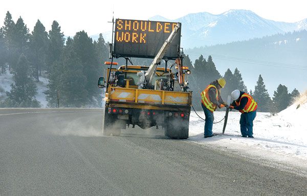
- Over the past two decades, the Oregon Department of Transportation has worked to improve safety conditions on the 168-mile section of Interstate 84 from Pendleton to Ontario. The department has built a new lane on several sections of the interstate through the Blue Mountains, including Cabbage Hill near Pendleton, the longest and steepest grade about seven miles, averaging 6 percent through the Blues. CHRIS BAXTER/The Observer
by JAYSON JACOBY / WesCom News Service
Oregon Department of Transportation has spent millions of dollars to make Interstate 84 safer for travelers
Oregon’s road workers can’t do much to tame the nasty winter weather that has made Interstate 84 between Pendleton and Ontario so notorious among travelers.
But highway crews have moved mountains.
Well, maybe not moved, exactly.
They’ve hacked hefty chunks out of a few, though.
That the 168-mile section of the freeway through the Blue Mountains of the state’s northeastern corner is rough country, in both the topographical and meteorological senses, directly influences how the Oregon Department of Transportation manages the route, said Tom Strandberg, a spokesman at ODOT’s Eastern Region office in La Grande.
“It’s a challenging area at all times of the year,” Strandberg said. “It’s pretty unique out here with the number of mountain passes and steep grades we have.”
Those steep grades, quite literally, are set in stone.
Even an outfit like ODOT that has quite a fleet of earth-movers at its disposal can’t make so much as a dent in the basalt backbone the freeway climbs between La Grande and Pendleton.
What the agency can do is widen the road’s footprint.
Over the past two decades ODOT spent several million dollars to build a new lane on several sections of I-84 through the Blue
Mountains.
These include Cabbage Hill near Pendleton, the longest and steepest grade – about seven miles, averaging 6 percent – through the Blues.
Generally, I-84 through the region is a four-lane route, two lanes in each direction.
Adding a third lane in the uphill direction helps to prevent traffic slowdowns that happen when, to cite the most common situation, one commercial truck is passing a slower truck, with both traveling well below the 65 mph speed limit for passenger cars and light trucks.
Loaded trucks sometimes struggle to maintain a speed even half the legal limit on I-84’s grades.
Adding an extra lane has a safety benefit as well, Strandberg said.
With trucks and other slower traffic confined to one or two lanes, drivers of faster vehicles are less likely to have to slow quickly because one truck is passing another.
ODOT has employed a similar strategy at the base of several steep grades by widening the freeway to give trucks a place to park while their drivers install chains, which are required occasionally when the road is slick.
Before these chain-up zones were built, truck drivers often had to park right beside, and in some cases partially intruding on, a travel lane.
That’s an inherently dangerous situation, Strandberg said.
The chain-up zones have been a major improvement, said Wendee Morrissey, who has been a school bus driver for the Baker School District for 27 years.
“The trucks can actually get off the road now,” said Morrissey, whose job requires her to drive the entire Blue Mountains section of I-84.
ODOT’s other main goal in designating chain-up zones is, naturally, to encourage truck drivers to put on chains before ascending the hills.
A single truck that spins out on a slippery grade can not only cause a multi-car crash, it can block one side of the freeway for hours.
A straightforward approach
As for moving those mountains, ODOT officials recognized years ago that the mountain passes aren’t the only places where accidents are common.
Nor is weather the only potential hazard along the freeway – in fact, fatal crashes are more common during the spring and summer than during winter.
Sections of freeway with many sharp curves are prone to problems, too. The Burnt River Canyon, a 12-mile section between Durkee and Huntington southeast of Baker City, is a prime example.
To mitigate the hazards, ODOT spent more than $10 million in 2008 and 2009 to dig into the rocky slopes on the north side of the freeway, making it possible to realign the freeway and ease the severity of two corners near the Weatherby rest area.
That project made the drive seem much less daunting, said Sandi Fuller, who commutes two or three times each week from her home in Weiser, Idaho, to her job in Baker City, a route that includes the Burnt River Canyon section of I-84.
“It was really helpful to smooth out those corners,” Fuller said.
Weather, of course, is even more stubborn than stone in one sense – you can’t hire a construction outfit to block a blizzard.
But you can erect fences that intercept some of the snow that otherwise would be whisked by wind across the travel lanes, there to be pounded into ice by passing tires.
Snow fences are hardly a new idea, to be sure – some of those bordering Oregon highways date back more than half a century.
But over the past several years ODOT has added to its array of snow fences along sections of I-84 where wind-blown drifts are a particular problem.
Ladd Canyon, the pass between North Powder and La Grande, is noteworthy is this respect, as is the Grande Ronde Valley.
ODOT built several hundred feet of fences on the south end of the valley, near the Charles M. Reynolds rest area at the base of Ladd Canyon, and 3,300 feet of lodgepole pine fencing near the summit of the pass.
The latter project was unique due to the material.
Most fences are built of metal, and are located within the public right-of-way next to the road.
But in Ladd Canyon that right-of-way isn’t wide enough to accommodate fencing, so ODOT had to negotiate with the landowner, Seven Diamond Ranches.
The ranch’s owner opposed metal fencing but didn’t balk at the lodgepole design, which blends in better with the surroundings.
Regardless of the material, the fencing was needed, Strandberg said.
The winds that blow almost incessantly through Ladd Canyon – the narrow defile acts as a sort of natural funnel – can wreak havoc on travelers even in clear weather.
Before the snow fences were installed, that section of freeway often remained icy long after a storm because the wind continued to whisk snow across the road.
Strandberg said an Oregon State Police trooper once watched his patrol car, which he was standing beside while talking to a motorist, slowly slide sideways across the icy freeway, the car’s two-ton bulk propelled along the nearly frictionless surface by the wind.
Know before you go
Another key cog in ODOT’s safety strategy for I-84 is to make it as easy as possible for travelers to know when, and where, driving conditions are less than optimum.
This effort includes:
andbull; Installing electronic message boards that can be programmed to alert drivers to, for instance, ice or dense fog. There are more than half a dozen such signs, on each side of the freeway, between Pendleton and Ontario.
And ODOT isn’t finished – the agency plans to put up another sign this summer near Baker City.
andbull; Creating a network of webcams that allow travelers, via computer, tablet or smartphone, to see the current conditions on a particular stretch of freeway.
There’s an even dozen cameras between Pendleton and Ontario, including multiple cameras in the areas where bad weather is more common – Meacham, Ladd Canyon and the Burnt River Canyon.
This winter ODOT added its newest camera in the area, one that takes in the north side of Ladd Canyon.
“There’s really no excuse not to be prepared for and aware of road conditions,” Strandberg said.
ODOT officials also plan to try a new tactic, starting in 2015, on the 20-mile stretch between Baker City and North Powder – temporary speed limit reductions that police can enforce.
The basic idea, Strandberg said, is that when the freeway is glazed with ice or obscured by fog, ODOT can temporarily reduce the speed limit – electronic signs would alert drivers to the change – and police could ticket drivers who don’t heed the lower limit.
Germany uses a similar system on some of its famous autobahns, and the tactic has proved to help reduce accidents, Strandberg said.
Brad Payton, who manages ODOT’s Baker City maintenance station and has worked for the agency for 30 years, said he expects the variable speed limit pilot project – one of two planned in Oregon, the other in the Willamette Valley where the issue is heavy traffic, not heavy weather – will be effective.
Although the section of I-84 between Baker City and North Powder is generally flat and straight (one exception is a moderate hill just north of the Baker Valley Rest Area), accidents are common in the area when the pavement is coated with snow or ice, Payton said.
“We get a lot of slide-offs in that stretch,” he said.
He suspects many drivers, having successfully negotiated Cabbage Hill and Ladd Canyon, or Three-Mile Hill and Burnt River Canyon, relax a bit when they reach the seemingly innocuous stretch of freeway through Baker Valley.
Strandberg said ODOT officials listen to the firsthand experiences of employees such as Payton, as well as scrutinize traffic and accident statistics, in their quest to reduce the hazards of this unusual section of freeway.
“We use all that data to help plan projects that are going to improve safety,” Strandberg said. “That’s our key goal. ODOT is open to innovative solutions to Eastern Oregon’s unique winter challenges. We also work closely with local city, county and tribal stakeholders to prioritize where project funding go.”
When a mountain needs a little trim, for instance.