Umatilla National Forest temporarily closes Forest Service Road 54 due to flood damage
Published 3:30 pm Friday, May 22, 2020
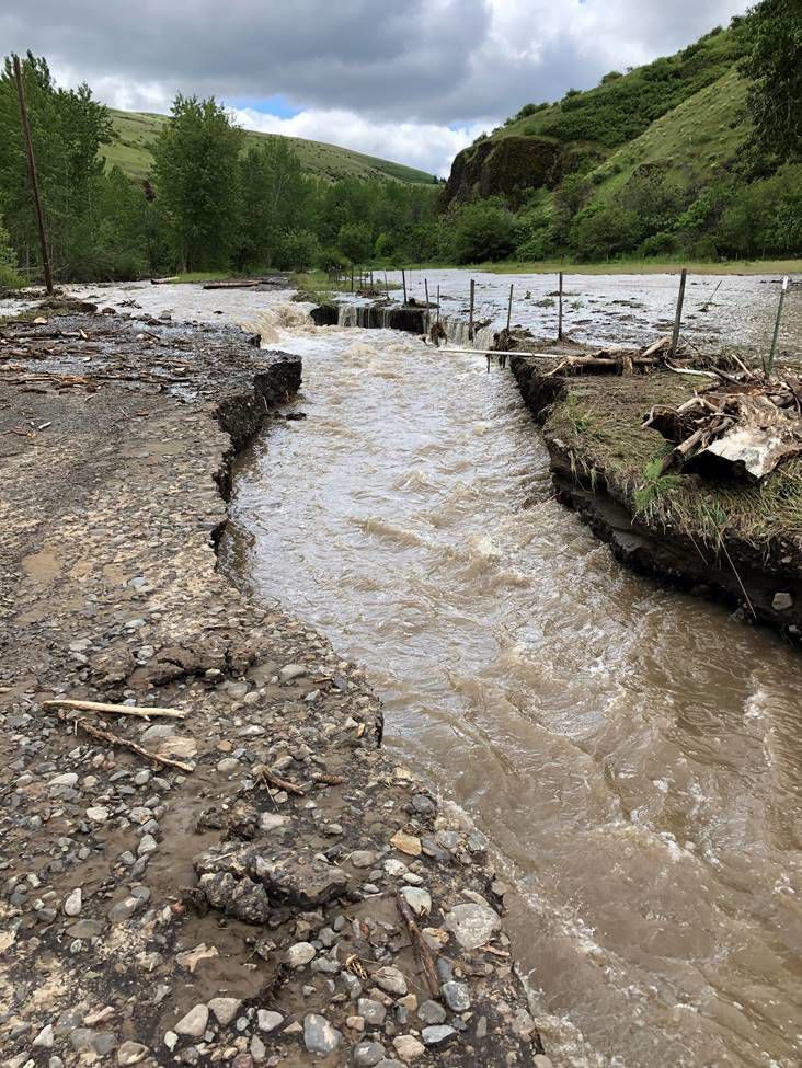
- The North Fork John Day Ranger District has temporarily closed Forest Service Road 54 due to several significant washouts caused by the recent rainfall and flooding.
PENDLETON — The North Fork John Day Ranger District has temporarily closed Forest Service Road 54 due to several significant washouts caused by the recent rainfall and flooding, according to a Umatilla National Forest press release.
Trending
The road, also known as Pearson Creek Road, is located approximately 14 miles southeast of Pilot Rock. Closure barriers and signs will be posted on the ground and visitors can take alternative routes into the area, including FSR 54 north from Highway 244 near Ukiah or FSR 5427 near Indian Lake.
Other known roads with localized flood damage on the district include FSR 10 between Dale and Olive Lake Campground and side roads off FSR 53 between Ukiah and Heppner, particularly the Sugarbowl Creek area and near Ditch Creek.
The forest received widespread rain on Wednesday, May 20, causing many rivers and creeks to rise near their banks or flood. Forest officials are advising the public to use caution when traveling in the forest. Roads and trails could be impacted by washouts or obstructions, such as rocks or boulders.
Trending
Some forest roads are still not accessible due to mud, snow or snow drifts. In addition, traveling on thawing, saturated and muddy roads can result in resource damage and serious safety concerns, especially if visitors are unprepared. Many places in the Blue Mountains have limited or no cellphone coverage.
Marketplace


-
eEdition

-

-
