On the trail: Back to the meadow — the annual April hike to Eilertson Meadow
Published 3:00 am Saturday, April 23, 2022
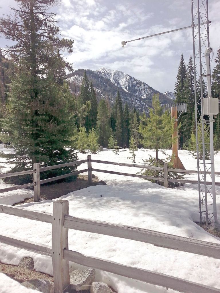
- The Eilertson Meadow Snotel on April 22, 2017. The water content of the snow was 3.1 inches.
Even before my snowshoe broke I was good and ready to get mad.
The busted footwear merely afforded me a focus for my simmering anger.
Although it takes a certain creativity to get terribly perturbed about an aluminum peg the approximate size of a Tic Tac breath mint.
As with many episodes of wrath, this one was largely irrational.
A triumph of emotion over reason.
The whining of an entitled brat.
Not that I recognized it as such at the moment when I looked down and saw that the snowshoe on my right boot was askew.
Severely so — the snowshoe, which is supposed to point in roughly the same direction as your toes, was about 90 degrees off, the way a person’s actual foot is in those awful sports videos I can’t watch without feeling sick at my stomach.
I had thought, for the past 10 minutes or so, that that shoe seemed to be sliding around in an awkward fashion every few steps.
But I put this off to the quality of the fresh snow coating the Rock Creek Road, which follows its namesake stream into one of the great chasms that cleave the east slopes of the Elkhorn Mountains northwest of Baker City.
That quality being terrible.
Snowshoeing through powdery snow, even many inches of it, can be almost a pleasure, particularly if the terrain is gentle. Dry snow has little heft to it — it doesn’t clutch at your shoes, like a toddler who is forever grabbing your pantsleg and throwing you slightly off balance with each tug.
The snow on the Rock Creek Road was closer to quicksand.
As is typical for snow that falls nearly a month after the spring equinox, it was sticky and dense, heavy with moisture.
This is fine snow for bolstering the scarce snowpack.
It is much less so for slogging through.
Especially when one of your snowshoes suddenly turns from a somewhat useful accessory into an appendage more akin to an anchor.
My wife, Lisa, helped me effect a repair, by means of a keychain, that would have worked perfectly for MacGyver and helped him foil a whole cadre of henchmen.
Alas, I am not him, lacking both the classic 1980s mullet and a team of screenwriters.
We made it some fraction of a mile before the snowshoe, missing that crucial peg, resumed its previous dangling posture.
Lisa, although both of her snowshoes were intact, was tired of hoisting a couple pounds of slush with each step, so we decided to cache them in a drift and continue unencumbered.
(Well, we kept our boots and socks on. We’re not, you know, crazy.)
It was one of those days in the mountains when the utility of snowshoes is not as certain as I would like it to be.
That I had felt the need to strap them on in the first place had merely primed me for the subsequent tantrum when the snowshoe failed.
We were hiking there along Rock Creek, on the day before Easter, because it’s become a tradition.
Or possibly a compulsion.
The difference between the two can be a trifle murky, as anyone knows who, for instance, sets off large explosives when the old year gives way to the new.
My purpose in coming back each April to Rock Creek is to take photographs.
A particular sort of photograph — the repeat.
The idea is to replicate a viewpoint so as to compare whether the place has changed, and if so to what degree.
Repeat photography more typically is employed to illustrate changes spread over many years, decades or even centuries, since the duration of the interval often coincides with the scale of the difference.
The subject of my experiment in repeat photography is rather mundane by comparison.
In April 2017 I hiked to the automated snow-measuring station at the eastern edge of Eilertson Meadow, along Rock Creek — what’s known as a Snotel. I did this for no reason other than I like to get out in the mountains in the spring, when the air is especially fresh and the occasionally cloying summer heat inconceivable.
I of course had my phone, and of course it was equipped with a camera (this particular phone is today a dusty relic relegated to my bedside table, since I subscribe to the notion that it is unAmerican, or at least anticapitalist, to not replace consumer electronics regularly, no matter how well the current version is working).
Anyway I took several photos of the site, which is inside a low split-rail fence, mainly, I think, to prove that I was there.
I returned the next April. Again I had no defined purpose. But again I had the phone, and it occurred to me — I think because the measuring site, unlike the previous year, was snow-free — that I ought to take photos from the same vantage point by way of comparison.
Four years later this annual excursion has become something of a habit.
Although the amount of snow has differed each year, and in some cases dramatically, each of the five trips had a commonality — they happened on a sunny day.
Moreover, each trip was preceded by at least a few dry days, with no fresh snow.
There was old snow, to be sure — even in 2018, when the measuring site was bare. The Rock Creek Road is well sheltered by thick forest and in places by terrain, so the sunshine works only slowly.
The road is also a popular route for snowmobiles, and the machines, over the course of the winter, compress the snow so thoroughly that, by mid April, the surface is nearly as firm as concrete, except frozen and a bit slippery.
In each of the previous five years, snowshoes were superfluous on this solid surface. It’s not an easy stroll, to be sure. The round trip distance varies depending on how far up the canyon the snow has receded, but it’s never been less than six miles — we walked about seven and a half miles this year — and the elevation gain is about 1,100 feet. But despite the lingering snow the hike, in the previous five years, was little different from walking on bare ground.
Not in 2022.
On the morning of Saturday, April 16, three inches of snow accumulated in Baker City. We figured it would be deeper still in the mountains.
It was.
Hence the snowshoes.
The moderate grades, which are scarcely noticeable when you’re walking atop the snow, seem grueling when you’re wearing snowshoes and plunging through half a foot of slightly congealed slop with each step.
Within a mile I was wheezing, and I could feel the initial drops of sweat making their way down my back.
Then there was the episode with the snowshoe.
But it was still a fine morning in the mountains, as most mornings there are.
A light snow was falling when we started but it stopped not long after. The temperature was in the low 30s — almost too warm for strenuous work but not unpleasant.
The latest in our recent caravan of spring cold fronts was sweeping through that morning and although the winds were gentle along the road, we could see, on the ridges above, swirls of snow propelled by the westerly gusts.
When we got to the measuring station at Eilertson the snow wasn’t far below the lower rail of the fence. Only in 2019 was the snow deeper.
Later in the day I checked the official record — Snotels beam their data every hour by radio signals, thence to a website — and the water content in the snow, in the hour that included our visit, was 3.8 inches. Only 2019, with 9.5 inches on the day I was there, April 21, had more.
Curiously, the first year I made the trip — 2017 — followed the snowiest winter, in the region’s valleys, in more than two decades. Yet the mountain snowpack that winter wasn’t as bountiful as the valleys’ deep drifts would suggest. On April 22, 2017, the water content at Eilertson was 3.1 inches.
The most distinct difference, though, revealed by photographs from the six years, wasn’t snow on the ground.
It was snow on the trees.
There wasn’t any in the photos from 2017-21.
The 2022 images, though, depict a decidedly wintry scene, the trees laden with snow and the peaks of the Elkhorns, which seemed almost etched against the blue sky in the previous five Aprils, were cloaked in cold fog and snow squalls.
We snacked on pretzels and cheese curds and chocolate chip cookies. I loitered, on the childish belief that a cavalcade of snow machines would roar past while we waited, packing the snow into the unyielding surface I had come to expect along Rock Creek in April.
But the only sound was the wind, soughing through the pines and spruces and tamaracks, the latter looking as forlorn as only that deciduous conifer can look before its yearly crop of new needles erupts, painting the slopes with a green that exists on no palette.
We enlivened the hike back to the rig by discussing the restaurants where we might indulge our caloric deficit that evening, a sort of fever dream.
No burger tastes better than the one you daydream about while trudging through the implacable snow.
From the railroad tracks in Haines:
• Drive west on Anthony Lakes Highway for 1.7 miles to the first major corner. Turn left onto Pocahontas Road, then stay right, after about two-tenths of a mile, on South Rock Creek Lane.
• Follow paved South Rock Creek Lane for about 3.7 miles, then continue into the mountains when the road turns to well-graded gravel.
• Continue on gravel for about 2 miles to a Forest Service sign for Killamacue trailhead and Rock Creek Lake trailhead. The road becomes a dirt track here, suitable for four-wheel drive, high-clearance vehicles. Snowdrifts likely will continue to block the road, at some point below Eilertson Meadow, for at least a few more weeks.
• From the Forest Service sign, the Killamacue Lake trailhead is 2 miles, and Eilertson Meadow 3.5 miles. The Snotel is just east of the meadow, on the south side of the road
• The Rock Creek Road is a public route. However, it passes through private land near the Killamacue Lake trailhead, and at Eilertson Meadow, so stick to the road. Oregon Trail Electric Cooperative owns the property at Eilertson Meadow, including the cabin at the meadow’s eastern edge.