Public gets update on region’s fires
Published 7:00 pm Saturday, September 3, 2022
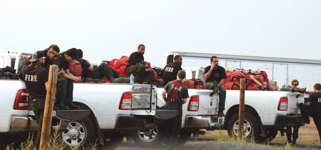
- U.S. Forest Service firefighters relax Friday, Sept. 2, 2022, at a fire camp set up at the Chief Joseph Days Rodeo Grounds in Joseph.
JOSEPH — A summary of current firefighting efforts given Friday, Sept. 2, wasn’t filled with a lot of bright spots, but it wasn’t all doom and gloom when officials from the Wallowa-Whitman National Forest gave a briefing on the status of five blazes in Wallowa County.
Trending
Anthony Botello, deputy forest supervisor for the Wallowa-Whitman, said the fires — most that started with lightning storms of about Aug. 22 — are “emerging incidents” that have yet to be counted as a major loss.
“We’ve been meeting objectives, so I guess those are bright spots,” he said. “The most important thing is nobody’s been hurt and we haven’t lost (property) we set out to protect.”
Joseph Black, public affairs specialist for the Wallowa-Whitman, said the Pacific Northwest Team 2, a Type 1 firefighting Incident Management Team had just arrived to take over management of the fires. The team is scheduled to take over at 6 a.m. Sept. 3.
Trending
According to the National Interagency Fire Center’s website, Type 1 teams are available for all size fires, but are typically used on large wildfires and other emergencies.
Fire officials said they expect to hold briefings similar to that of Sept. 2 on a weekly basis. There were 23 people present, along with 10 fire officials and more than 40 who attended virtually, Black said.
As of Sept. 2, the Sturgill Fire was the largest at 5,481 acres and located about 15 miles southwest of Enterprise. The Sturgill Fire has 35 personnel battling it.
Chris Barth, public information officer for the Pacific Northwest Team 2, said in an email Sept. 2, the Sturgill Fire in the Eagle Cap Wilderness firefighters are working at the Minam River Lodge to complete structure protection assessments for private inholdings along the river. Smokejumpers are assigned to the east side of the fire to help check fire spread in the Bear Creek Drainage.
The Nebo Fire, at 3,433 acres is next and is burning in the Lick Creek Drainage. It has 25 people fighting it. Barth said on the Nebo Fire, also within the Eagle Cap Wilderness, firefighters are working on Forest Service Road 100, FSR 200 and FSR 3925 to prepare for firing operations, if necessary, to limit fire spread outside of wilderness to the north and east. They will continue monitoring spot fires in the Imnaha corridor and use aircraft to limit fire spread south of the Imnaha Divide. Helicopters are assisting firefighters on the ground with bucket drops of water to suppress spot fires on the north and south sides of the fire.
The Double Creek Fire has nearly doubled since Sept. 1 and now is burning 2,947 acres near Double Creek and the Hat Point area above Imnaha. No number of firefighters was given for Double Creek.
On the Double Creek Fire, Barth said, firefighters have been focused on providing structure protection along the Imnaha River Road and Freezeout Road. They are also working to keep the fire east of the Upper Imnaha Road and have been improving dozer lines on the west side of the fire. On the north side of the fire, firefighters have been scouting ridges to identify control features. Aircraft was used again Sept. 2 to check the spread of the fire.
All of the blazes are zero percent contained, according to information distributed at the briefing.
Two smaller fires, Goat Mountain 1 and Goat Mountain 2, are burning just northeast of the Nebo Fire, but are quite small. Goat Mountain 1 was just a 10th of an acre and Goat Mountain 2 was about 100 acres, Black said.
A fire camp has been set up at the Chief Joseph Days Rodeo Grounds in Joseph where firefighters will rest and take their meals.
Evacuation notices have been sent out by the Wallowa County Sheriff’s Office with the assistance of Oregon State Police. Sheriff Joel Fish said earlier this week that OSP loaned him six troopers to help notify area residents of the imminent fire danger.
Freezeout Road south of Imnaha was closed early Sept. 2, because of danger from the Double Creek Fire, according to a notice texted by the sheriff’s office.
The road closed at 9:14 a.m., according to a press release.
A 7:17 a.m. text read had been sent out urging residents to evacuate.
“There will be fire units moving in,” the text read.
The road, also known as National Forest Road 4230, runs southeast from the Upper Imnaha Creek Road along Freezeout Creek.
The road was recommended for evacuation in a notice issued by the sheriff’s office Sept. 1 and then reduced to the Level 2 “Get Set to Leave” later that day. Early Sept. 2 it was returned to the Level 3 “Evacuate Area.”
For more information, visit InciWeb, a new fire information line at 541-216-4579 or email 2022.doublecreek@firenet.gov.
Marketplace


-
eEdition

-

-
