Hat Rock Fire blows up to 10,000 acres
Published 8:00 am Wednesday, June 14, 2023
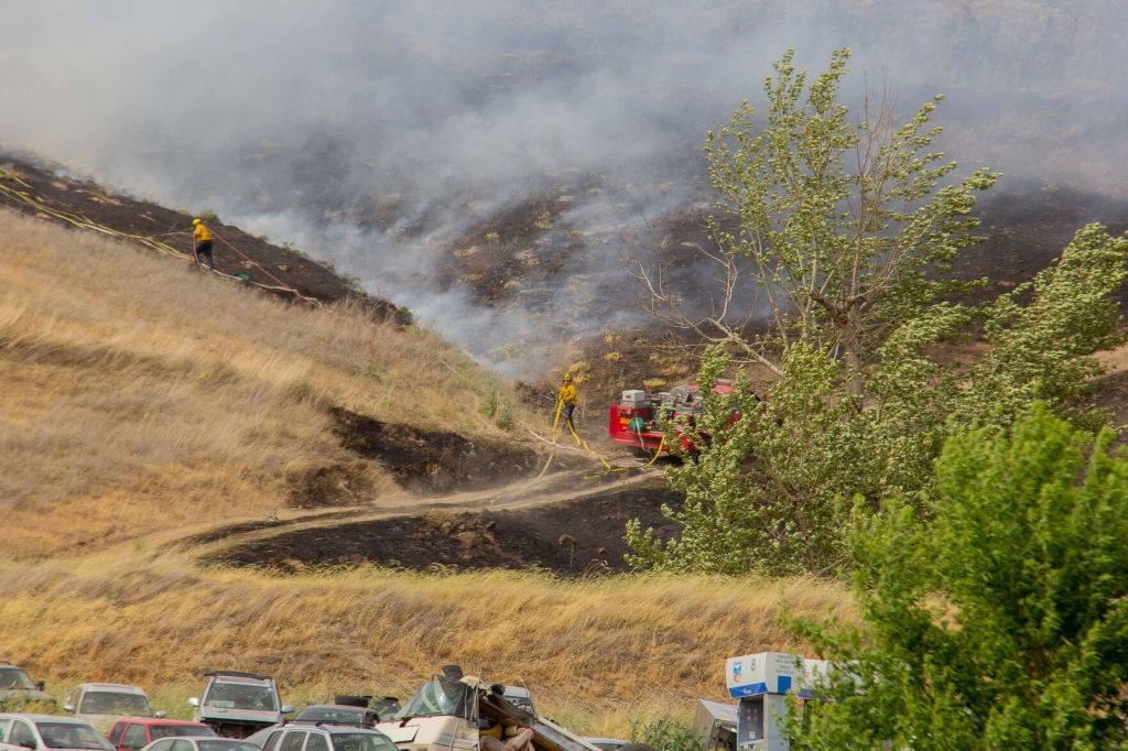
- Firefighters hurry up a burning hill Tuesday, June 13, 2023, off Highway 11 in Pendleton to combat the Mount Hebron Fire.
HERMISTON — What started as a response to douse a grass fire Tuesday, June 13, near Hat Rock State Park in northern Umatilla County would progress to a massive wildfire requiring help from virtually all local fire departments and more.
The hot, dry weather and high winds fed the Hat Rock Fire, which Umatilla County Fire District No. 1 estimated at one point in the evening to have grown to approximately 10,000 acres.
The National Weather Service in Pendleton on June 12 had issued a fire weather watch for June 13 for Gilliam, Morrow and Umatilla counties. The NWS changed that June 13 to a red flag warning that was in effect until 9 p.m.
“Firefighters are being challenged by gusty winds and low relative humidity,” according to a report from the Oregon Office of State Fire Marshal, which also asked everyone to pay attention to these conditions and take the necessary precautions to avoid sparking a fire.
The Hat Rock Fire prompted the closure of Highway 730 near the state park, and the Umatilla County Sheriff’s Office would issue an evacuation notice for areas in Juniper Canyon along Hartle, Wallula and Hatchgrade roads due to the fire.
The sheriff’s office reported deputies and search and rescue members went door to door advising occupants to evacuate the area. This was not a mandatory evacuation but a notice of immediate evacuation, the sheriff’s office explained, which meant occupants were requested and instructed to leave the area for their own safety.
The city of Hermiston opened the Eastern Oregon Trade and Event Center for anyone evacuated who may need shelter.
The State Fire Marshal mobilized six task forces and the OSFM Green Incident Management Team to the Hat Rock Fire as well as the Mount Hebron Fire, according to Umatilla County Fire District No. 1.
The high winds and low visibility grounded the K-MAX helicopter from La Grande and two aircraft the U.S. Fish and Wildlife Service sent to fight the blaze.
Oregon Gov. Tina Kotek declared a conflagration for the Hat Rock Fire and the fire burning at the same time on the Mount Hebron area in Pendleton. That fire, however, would spread to only approximately 500 acres.
Fire District No. 1 reported it received a callout at 10:59 a.m. for a brush fire on Highway 730 near Highway 37. The fire district reported its crews battled the fire in multiple divisions along Highway 730, and numerous local agencies assisted.
Umatilla Rural Fire Protection District, Echo Fire Department, Irrigon Fire Department, Boardman Fire Rescue District, Pendleton Fire and Ambulance, Pilot Rock Rural Fire Protection District, East Umatilla County Rural Fire Protection District and Umatilla Tribal Fire Department each sent crews and equipment to the Hat Rock Fire.
The Walla Walla Fire Department, Oregon Department of Forestry, Gilliam County Fire Services and Oregon National Guard also have provided resources.
The Umatilla County Sheriff’s Office reported it activated the county’s Emergency Operation Center at noon to assist in monitoring the ongoing fires in the region and coordinate response efforts. Wind and low relative humidity, as well as a strong cold front moving across the Pacific Northwest were contributing factors to the red flag warning, according to the NWS.
The forecast called for temperatures up to 88 degrees with relative humidity as low as 27%, according to NWS. Winds were projected to blow westward at 25-35 mph with gusts up to 50 mph.
“A cold front will sweep across the forecast area on this afternoon resulting in increasing westerly winds combined with low relative humidities,” the Weather Service reported.