Persistent El Nino weather pattern has resulted in slow start to snowpack season in Northeast Oregon
Published 6:00 am Thursday, January 4, 2024
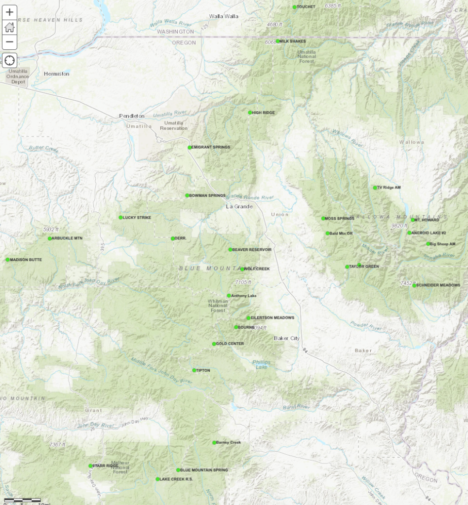
- This map shows snowpack measuring sites in Northeastern Oregon.
BAKER CITY — Mike Widman is used to dealing with snowdrifts deep enough to bury a pickup as the new year begins, but mostly what he’s been finding at the dawn of 2024 is mud.
Trending
With an El Nino weather pattern diverting the usual winter storms away from Northeastern Oregon, the snowpack in the region, a vital source of water to replenish reservoirs and nourish crops, is scarce.
The weather has been balmy, too, including the warmest December on record at the Baker City Airport, and the warmest at the Eastern Oregon Regional Airport in Pendleton since 1975.
“It’s pretty bare and open,” said Widman, whose family has been in the cattle business in Baker County for well over a century. “I’ve never seen a December this mild.”
Trending
Statistics bear out what Widman is seeing — and not seeing, when it comes to those snowdrifts — while tending to his cattle.
As of the first day of 2024, the water content in snow measured at more than 20 sites around the region, ranging from south of John Day through the Elkhorns and Wallowas and north to the Blue Mountains in southeast Washington, was 49% of the long-term average.
None of the sites exceeded 76% of average. Four were below 30%.
(When it comes to snowpack, water content is a more relevant measure than snow depth, since powdery snow, which is common at higher elevations, contains relatively little moisture. Water content is a better predictor of the spring runoff.)
“It doesn’t look very promising,” Widman said Tuesday morning, Jan. 2. “We need some snow.”
But with temperatures well above normal for the past several weeks in most places, rain has been about as common as snow.
This December was the warmest at the Baker City Airport since at least 1942. The average temperature during the month was 34.4 degrees, topping the previous record of 33.7, set in December 1973, and nearly 8 degrees above average.
At the Pendleton airport, the average temperature during December was 39.4 degrees, the highest since 1975 (40.5 degrees). The mildest December on record at the airport, where statistics date to 1928, is 1973, when the average was 41.5. The overall average is 34.9 degrees.
Not a normal start to the year
Widman said he has been doling out about half as much hay to his cattle as usual since they can get by with less feed during the relatively mild weather.
Jess Blatchford, who grows potatoes, wheat, silage corn and other crops in Baker Valley between Baker City and Haines, needs only look a few miles to the west, where the Elkhorn Mountains rise more than 5,000 feet above the valley, to see the effects of El Nino.
Slopes that typically are white well before Christmas — and not infrequently before Thanksgiving — were nearly bare as 2024 began.
“It doesn’t look much like the first week of January,” Blatchford said on Jan. 2.
He said he talked with a friend who lives near Cove, in Union County, who mowed his lawn on the last day of 2023.
But although Blatchford depends on snowmelt from the Elkhorns to keep his sprinklers going in the spring and summer, he isn’t overly worried about water.
Not yet, anyway.
“It’s not off to a good start, but we can usually catch up in January, February and March,” he said. “I’m hoping we’ll start getting some weather.”
Blatchford wouldn’t begrudge a few outbreaks of arctic air, either.
The lowest temperature during December at the Baker City Airport was 14 degrees. That was the “highest low” for the month since at least 1942. In more than half the Decembers since then, the temperature at the airport has dropped below zero on at least one day, and temperatures of 10 below or colder aren’t uncommon.
Blatchford said frigid temperatures can sink frost into the soil, killing insects, fungal diseases and other pests that harm crops.
Mild air has intruded on the mountains as well as the valleys.
The lack of organized storms has resulted in stagnant conditions that led to temperature inversions, in which relatively colder air, being more dense, was trapped in valleys while the ridges and peaks above basked in sunshine.
An automated snow-measuring site near Anthony Lakes Mountain Resort, elevation 7,100 feet, for instance, recorded temperatures above freezing on all but one day from Dec. 12-27. That included a high of 50 degrees on Dec. 17, and temperatures of 45 or higher on five other December days.
El Nino in control
The scanty snowpack is no surprise to meteorologists.
They had been predicting since last summer that an El Nino pattern was likely this winter. That’s the cyclical movement of unusually warm water temperatures in the Pacific Ocean.
During most El Nino winters, the polar jet stream, the high-altitude zone of strong winds that steer winter storms, diverts tempests north into Canada and Alaska, said Jay Breidenbach, warning coordination meteorologist at the National Weather Service office in Boise.
Also common during El Nino winters is a “split flow” situation, in which a separate jet stream, the subtropical, sends soggy storms into California.
The Northwest, meanwhile, including Oregon and Washington, lies between the storm tracks and has unseasonably warm, and in most places unusually dry, weather.
“This is exactly what we expected,” Breidenbach said.
Matt Callihan, a meteorologist at the National Weather Service office in Pendleton, said the pattern has prevented storms that do move in from the Pacific from progressing very far inland.
“Essentially, they kind of get to the Cascades and then they don’t really have enough moisture to get over the Cascades really into the base of the Blues,” he said. “So we have very minimal amounts there and we’re also continuing to see above-average temperatures, which is normal for an El Nino year.”
Water worries
The snow that accumulates in the region’s higher mountains, including the Blues, Wallowas, Elkhorns and Strawberrys, trickles into streams each spring, keeping rivers flowing and refilling irrigation reservoirs.
The snowpack season actually had a promising start, with a couple of early storms that brought significant snow to the mountains in late October.
But that snow didn’t last long.
And since about mid-November, storms have rarely arrived, and they’ve been weak when they did.
“We’ve had a fairly good October and early November, but since then we’re not seeing our normal amount of precipitation,” said Don Wysocki, a soil scientist with the OSU Extension Service in Umatilla County. “From forecasts I’ve heard it’s supposed to be warmer than normal, which is not good for the snowpack.”
“We really need that snowpack to start building or that may impact our spring and summer months because of the lack of snowpack,” Callihan said.
El Nino can affect farmers and ranchers who depend on snowpack runoff for irrigation, as well as the dryland wheat farms in the Columbia Basin, which benefit from winter precipitation, whether rain or snow.
Rainfall was actually slightly above average at the Pendleton airport during October, November and December, although other parts of the basin were drier.
• October: 1.26 inches (average, 1.05).
• November: 1.71 inches (average, 1.44).
• December: 1.58 inches (average, 1.58).
Matt Melchiorsen, who manages the Wallowa Lake Irrigation District in Wallowa County, said that despite the scanty snowpack, he’s not yet worried about water supplies.
“It’s not that uncommon this early in the winter,” Melchiorsen said. “If it was this time in February, it would be.”
He is maintaining Wallowa Lake, a key source of irrigation water, about two to three feet higher than usual in anticipation of a below-average amount of spring runoff if the snowpack doesn’t deepen considerably.
“We’ll see how the next couple of months play out,” he said. “As the experts say, it all depends on the weather.”
Drought diminishesAlthough Widman worries about potential water shortages in 2024, he said the situation isn’t as dire as it could be.
A combination of an above-average snowpack last winter, ample rain during the spring of 2023 and an unusual bounty of rain in late August, when the remnants of Hurricane Hilary doused Baker County with record-breaking rainfall, ended the drought that had plagued the region over the past two years.
“2023 was awesome,” Widman said. “The grass grew belly deep on the range, and it was the best hay crop I’ve had. The range is in pretty great shape as we speak.”
The U.S. Drought Monitor map reflects the improvements that 2023 brought.
No part of Northeastern Oregon is in drought.
Most of the northern parts of Morrow, Umatilla, Union and Wallowa counties are rated “abnormally dry,” one step below the least severe of the four drought categories (moderate, severe, extreme and exceptional).
None of Baker County is rated as abnormally dry, and only a sliver at the northwest corner of Grant County has that rating.
The beneficent weather in 2023 also fortified reservoirs that had, in some cases, been all but emptied during the drought.
Phillips Reservoir near Baker City, for instance, which supplies irrigation water for more than 30,000 acres in Baker Valley, is about 34% full now.
A year ago the reservoir was less than 1% full.
Thief Valley Reservoir near North Powder, which irrigates farms and ranches in Keating Valley, has more than twice as much water now as it did a year ago — 9,900 acre-feet (74% of capacity) compared with 4,900 acre-feet at the start of 2023.
McKay Reservoir near Pendleton, by contrast, is lower than it was a year ago, at 17,200 acre-feet now (24% of capacity), compared with 23,710 acre-feet a year ago.
Big change from a year ago
The snowpack situation was quite different at the start of 2023.
After a soggy November 2022 in the Columbia Basin — rainfall that month at the Pendleton airport was 2.29 inches — the 2022 total reached 15.91 inches. That was the most at the airport in a calendar year since 2017 (16.48 inches) and 29% above average.
The snowpack also was much deeper at the beginning of 2023 compared with today.
The water content was above average at all but two measuring sites a year ago. Overall the water content was about 132% of average, compared with the current 49%.
A few examples from different parts of the region illustrate the dramatic difference.
• Aneroid Lake, Wallowa Mountains south of Wallowa Lake. Water content on Jan. 1, 2023, was 12.1 inches, 34% above average. This year the water content was 1.8 inches, 80% below average.
• Eilertson Meadow, Elkhorn Mountains west of Haines. Water content on Jan. 1, 2023, was 6.4 inches, 45% above average. This year the water content was 2.9 inches, 38% below average.
• Starr Ridge south of John Day. Water content on Jan. 1, 2023, was 3.4 inches, 21% above average. This year the water content was 1.2 inches, 56% below average.
Last winter was marked by a La Nina pattern, which is basically the opposite of El Nino, Callihan said.
“Usually with La Nina we see cooler and wetter conditions,” he said. “Under El Ninos we usually see the opposite, so drier and warmer. And that’s what we’ve been seeing thus far this year.”
Looking ahead
Breidenbach said meteorologists expect the El Nino pattern to weaken, possibly by late winter. That could help the mountain snowpack in Northeastern Oregon recover from its sluggish start.
It is relatively early in the snowpack season.
In many years the biggest storms, at least in the higher mountains, arrive during February, March and even April. The water content typically peaks from late March through early May, depending on elevation.
The weather pattern did start to shift late this week.
A modest storm brought light snow to the region, and the National Weather Service is forecasting several other storms, along with much lower temperatures, over the next week or so.
The agency is predicting more than a foot of snow in the northern Blue Mountains, Elkhorns and Wallowas during the period.
Whether the wintry pattern persists, though, is uncertain.
Callihan said that during a typical El Nino winter it’s more likely than not that placid conditions, similar to what predominated during December, will return.
“It’s pretty bare and open.
I’ve never seen a December this mild.”
— Mike Widman, Baker County cattle rancher
WALLOWA COUNTY — For the first time, a lack of snow is forcing the cancellation of the Eagle Cap Extreme Sled Dog Race, Dr. Randy Greenshields announced late Thursday, Jan. 4.
Greenshields, a veterinarian who does health checks of the dog teams and serves on the Eagle Cap Extreme board, said board members met and decided to cancel the race because of the scarcity of snow.
“Several other sled-dog races have been canceled as well this year,” he said.
Greenshields said mushers and volunteers were being notified so they wouldn’t make the trip to Wallowa County in vain.
He said six teams had signed up for the 200-mile race, 12 in the 100-mile race and another six in the 31-mile race. Mushers and teams were coming from California, Idaho, Montana, Utah and Washington.
More than 100 people signed up to volunteer as helpers with the races.
The event had been scheduled for Jan. 17-20. Veterinarian checks had been scheduled for Enterprise and Joseph on Jan. 17, with the races starting the next day at Ferguson Ridge Ski Area.
Greenshields said that although the race has never been canceled because of a lack of snow, on its second year — in 2006 — it was cut short because of too much snow.
He said two of the mushers missed hearing that the race had been cut short and were on their own on the course. One of them, Billy Snodgrass of Wyoming, said, “It was the scariest mushing moment I’ve ever had.”
Greenshields said Snodgrass told him that because of the way the snow was falling, he wasn’t sure he was going to make it back.
Greenshields said the race also attracts veterinarians from all over, some from the East Coast and the Midwest, as well as from around Oregon.
“It’s good learning” for the veterinarians, he said.
In addition to the mushers, race spectators will be disappointed by the cancellation. Schoolchildren generally come to downtown Enterprise and Joseph to see the dog teams.
“With all the kids who come to the vet checks,” he said, “it really brings a lot of people together.”
But Greenshields hasn’t lost hope.
“Hopefully we’ll be back next year with plenty of snow,” he said.
— Bill Bradshaw
Marketplace


-
eEdition

-

-
