Series of storms nearly makes up for December’s El Nino doldrums
Published 3:00 pm Tuesday, January 16, 2024
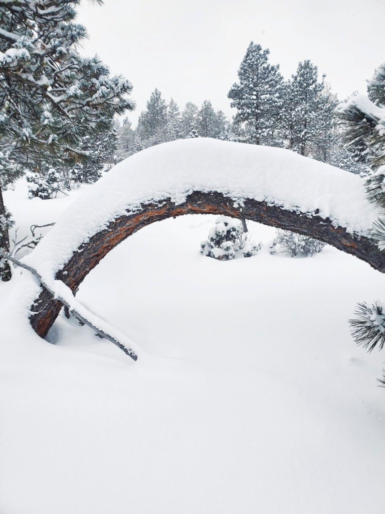
- A snowstorm on Jan. 11, 2024, piled snow on a bent ponderosa pine tree near Baker City.
BAKER CITY — El Nino took its holiday break a couple weeks late.
Trending
The weather pattern that meteorologists say was responsible for the unusually mild and dry December in Northeast Oregon has for now disappeared.
Buried beneath snow.
A series of storms more typical of the season has wrought dramatic changes to the landscape during the first two weeks of 2024.
Trending
At Anthony Lakes Mountain Resort, workers whose challenge in December was to move enough snow to cover just the main ski runs have instead focused on pushing piles of snow out of the way so people can park.
Not that Anthony Lakes officials are lamenting.
“This was a very welcome change of pace,” Chelsea Judy, marketing director for the ski area in the Elkhorn Mountains about 34 miles northwest of Baker City, said on Monday, Jan. 15.
“Like many ski areas in the region, snow farming was a prominent task this early season and our guys did an incredible job of moving snow around in December,” Judy said, explaining that “snow farming” is “when we find and move snow from very nook and cranny to keep the main runs open. Within days, we went from snow farming to extremely long hours of shoveling, plowing and snow removal operations.”
Numbers tell the tale of toil.
From Jan. 1-15, Anthony Lakes measured 55 inches of snowfall, Judy said.
The resort, which had a paltry snow base of 20 inches when it opened for the season Dec. 16, reported 63 inches on Jan. 15.
(Snow settles between storms, so the total snowfall exceeds the base depth.)
An automated snow-measuring station about half a mile east of the ski area recorded 39 inches of snowfall from Jan. 4-13.
The reprieve from El Nino effects was also reflected in temperatures.
The snow-measuring station, at an elevation of 7,100 feet, recorded temperatures above freezing on all but one day between Dec. 12 and Jan. 3, including a high of 50 on Dec. 17.
But since Jan. 4 the temperature has stayed below 32 degrees.
Snowpack surge
Skiers and snowboarders are hardly the only beneficiaries of the recent weather shift.
Snowmobile trail-grooming machines, which didn’t leave their sheds during December, have been busy.
Volunteers with the Sumpter Valley Snowmobilers spent about 14 hours grooming around 60 miles of trails on Friday, Jan. 12, and grooming continues this week, said club president Mike Bogart.
Bogart said weekend storms, which pushed the snow depth to about 3 1/2 feet at Blue Springs Summit, the high point, at 5,800 feet, on the highway between Sumpter and Granite.
“The last storm dumped a lot of snow,” Bogart said on Monday, Jan. 15. “We were a little bit concerned about what winter had in store for us. If this is any indication of the next month and a half or so, we’re good.”
The wintry weather has also transformed the region’s previously puny mountain snowpack.
On the first day of 2024, the water content in snow at 20 automated measuring sites around Northeast Oregon was 49% of average.
Two weeks later, that figure had risen to 88% of average.
The snowpack is a vital source of water for irrigation and recreation in Northeast Oregon.
After a significant drought from 2020-22 depleted reservoirs, an above-average snowpack last winter, followed by a damp spring, ended the drought and left reservoirs with more water, after the 2023 irrigation season, than the previous several years.
A second straight ample snowpack could potentially refill some reservoirs, such as Phillips, in the Sumpter Valley about 17 miles southwest of Baker City. That reservoir, which supplies irrigation water to Baker Valley, hasn’t filled since June 2017.
The bellwether snow-measuring site for Phillips Reservoir is near Bourne, in the upper headwaters of the Powder River Basin.
On Jan. 1 the water content at Bourne was a paltry 4.7 inches — 27% below average for the date.
Two weeks later the water content had nearly doubled, to 8 inches, and was just 2% below average.
The turnaround was even more dramatic at other sites.
On Jan. 1, the water content was below average at every site.
On Jan. 15 the water content was at or slightly above average at a couple stations, including Wolf Creek, northwest of North Powder, where the water content jumped from 24% below average on Jan. 1 (4.4 inches) to 4% above average on Jan. 15 (7.5 inches).
At Gold Center, near Granite, the water content doubled between Jan. 1 and 15, reaching 5.8 inches, exactly average, on the latter date.
The gains have been comparatively modest, though, in parts of the Wallowa Mountains.
Although the water content at Aneroid Lake, south of Wallowa Lake, more than doubled, from 1.8 inches on Jan. 1 to 3.9 inches on Jan. 15, the latter figure was still 61% below average.
In the southern Wallowas, at Schneider Meadow north of Halfway, the water content rose from 5.9 inches on Jan. 1 (48% below average) to 9.5 inches (38% below average).
Mark Bennett, who runs a cattle ranch near Unity, in southern Baker County, said there was no snow, save for a few patches in shaded spots, on his place on Jan. 1.
On Jan. 15 the snow was 19 inches deep.
The recent storms were welcome after a December that Bennett described as “dismal.”
And although the frigid weather — it was 7 below zero on Monday morning at his ranch — is tough on animals and on equipment, Bennett said he hopes the cold lingers long enough to sink into the soil.
With the ground unfrozen, much of the spring snowmelt is likely to soak into the ground rather than running into streams and, ultimately, reservoirs, Bennett said.
“We were a little bit concerned about what winter had in store for us. If this is any indication of the next month and a half or so, we’re good.”
— Mark Bogart, president, Sumpter Valley Snowmobilers club
Although the wintry weather is forecast to continue the first half of this week, the National Weather Service is predicting a warming trend — more typical of an El Nino winter — by this weekend.
Although this likely will result in more rain than snow in the valleys, snow levels aren’t forecast to rise as high as they often did during December, so snow should continue in the mountains, bolstering the snowpack.
The National Weather Service is predicting occasional precipitation continuing into next week.
Marketplace


-
eEdition

-

-
