Northeast Oregon fire officials expect a relatively normal wildfire season following a tranquil 2023
Published 7:00 am Wednesday, June 5, 2024
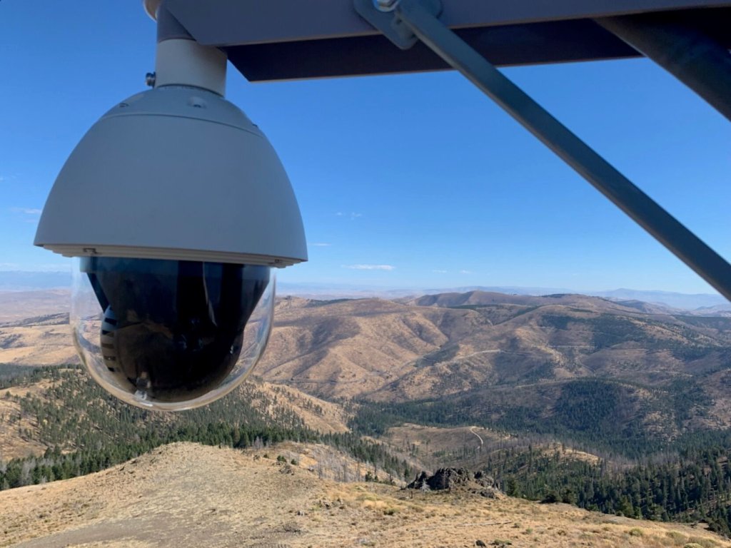
- A camera attached to a remote detection control station in the mountains of Northeastern Oregon captures long-range images to help the Oregon Department of Forestry and the U.S. Forest Service detect wildfires.
Al Crouch isn’t counting on another hurricane to douse the wildfire season in Northeast Oregon.
Trending
Crouch, the fire mitigation specialist for the Bureau of Land Management’s Vale District, expects instead a season closer to normal, with a higher chance of larger fires.
There was nothing normal about 2023.
“Last year was an anomaly,” Crouch said on May 28.
Trending
And nothing about the year was nearly so anomalous as the Aug. 21, 2023, rainstorm fueled by the decaying remnants of Hurricane Hilary.
Although the storm had long since lost most of its gusty potency when it swept through Northeast Oregon, it still carried copious amounts of moisture into the region.
Baker County was especially soggy, with record rainfall recorded at several sites, including 3.52 inches near Richland on Aug. 21.
The sodden day during what’s usually the driest, hottest part of the year didn’t end fire season.
But Crouch said the storm significantly curbed the fire potential for the rest of the year.
Statistics reflect the effects.
On the Wallowa-Whitman National Forest, for instance, which was directly in the storm’s path, the total of 49 fires for the year (20 sparked by lightning, 29 by people) was the fewest since 2018, when there were 39.
And those fires were quite docile by the standards of the past couple decades.
Just 494 acres burned, the sixth-lowest annual total in the past four decades .
The annual averages for the previous decade were 78 total fires, and 34,722 acres burned (the latter figure inflated substantially by three especially fiery years, 2021 (199,000 acres), 2014 (56,000) and 2015 (50,000).
“Last year was pretty slow for us,” said Joel McCraw, assistant fire management officer for the 2.3-million-acre Wallowa-Whitman.
The Umatilla National Forest was tranquil, too, with 35 total fires (10-year annual average of 62) burning 67 acres, the fewest in the past decade, during which the yearly average was 19,583 acres.
The Oregon Department of Forestry, which is responsible for fighting fires on state land and on much private property in the region, recorded 59 fires in Northeast Oregon in 2023 (the yearly average of the past decade was 71) and 513 acres burned (annual average of 8,849 acres).
“Last year was an anomaly,” said Cody Kingsbury, wildland fire supervisor at the ODF’s Baker City office. “It was more green in August than I’ve ever seen.”
Crouch said record August rainstorm wasn’t the only factor contributing to the unusually uneventful 2023 fire season.
Damp, cold weather during the spring delayed the onset of high fire danger, as well.
And Crouch said occasional rain during the first half of summer — before the hurricane’s remnants arrived — kept the fire danger largely at bay.
“We had lots of rain at key times, and we typically don’t see that,” he said. “It really moderated our fire season. Over season this year is definitely shaping up to be more normal.”
Returning to normal?
Fire managers, representing a trio of agencies, all agreed that, as May gave way to June, the 2024 fire season was proceeding on what they considered a relatively typical path.
“We’re preparing for an average season here in Northeast Oregon,” said Tyson Albrecht, deputy fire staff for the Umatilla National Forest. “And for us, that means a season that kind of kicks off middle of July, and wraps up by the middle of September, which is different than a drier kind of season, which will kick off earlier in June, and really run through October.”
May was wetter than average in most of the region.
At the Eastern Oregon Regional Airport in Pendleton, rainfall for the month totaled 2.62 inches, more than double the long-term average of 1.21 inches.
Rainfall was closer to average at the Baker City Airport, with 1.55 inches compared with an average of 1.43.
Fire managers emphasized that the next month will have an outsized effect on how severe the fire risk becomes during the height of the season from July through September.
“We’ll see what June brings,” McCraw said. “June’s kind of a catalyst to me.”
Kingsbury concurred.
“The big driver is what the month of June brings,” he said. “If we get plenty of moisture, it will delay the onset of the fire season. But if it’s hot and dry, that sets us up for a busier fire season.”
“June a lot of times will be the determining factor,” Albrecht said. “If it gets really hot and dry in June, that will certainly change things.”
Compared with July and August, and often September, which almost always are hot and relatively dry, June weather can fluctuate widely.
The average daily high temperature during June at the Baker City Airport, for instance, ranges from 66 degrees to 84 degrees over the period starting in 1943.
At the Eastern Oregon Regional Airport, June’s average high, dating from 1928, ranges from 70 degrees to 89 degrees.
Rainfall, too, can vary considerably during the month, ranging from less than one-quarter inch to a record of 5.06 inches at the Baker City Airport.
At the airport in Pendleton, June rainfall ranges from none to 2.7 inches.
Fire danger vs. acres burned
The fire officials emphasize that when they talk about the upcoming fire season they refer not to any sort of certainty about how many fires will start or how many acres blazes will burn.
They are, rather, referring to the fire danger, something they track with a variety of computer-derived indices that, among other things, estimate how quickly a fire would spread.
But without a source of ignition, fire danger, no matter how extreme, is merely a measure of risk, not a guarantee that fires will start.
“It all depends on lightning and humans,” Kingsbury said.
One or the other is responsible for starting wildfires.
And neither can be predicted with anything approaching accuracy.
Lightning sparks a higher percentage of fires in Northeast Oregon than some other parts of the state, such as the more heavily populated west side of the state.
Over the past decade, the Umatilla National Forest reported an annual average of 51 lightning fires compared with 12 human-caused blazes.
On the Wallowa-Whitman, the annual averages over the past decade were 56 lightning fires and 21 human-caused.
Although predicting precisely where lightning bolts will strike is impossible, Crouch said lightning-detection technology has improved considerably over the past few decades.
Meteorologists can forecast with considerable accuracy the ingredients that fuel thunderstorms — typically, high temperatures and high levels of moisture in the atmosphere, as well as cold fronts — so lightning typically is expected.
And because lightning detectors can give fire managers — and the public, through a variety of online apps — relatively detailed maps of where lightning bolts were most numerous.
That can help fire officials dispatch crews to areas where blazes are most likely to show up, Crouch said (lightning-sparked fires sometimes smolder for hours or days before producing much smoke).
Although lightning is the most common cause of fires in Northeast Oregon, widespread thunderstorms don’t automatically equate to a rash of wildfires.
The key, Crouch said, is another thing that thunderheads produce — rain.
“It’s the dry lightning events that really hurt us,” he said.
Storms that spawn hundreds of lightning strikes, but little if any rain, were the culprits in many of the most severe wildfire outbreaks in the region.
Examples include a storm in late July 1989 that sparked dozens of fires on the Wallowa-Whitman, including the 20,000-acre Dooley Mountain fire south of Baker City, and storms in August 2015 that touched off a couple of the biggest and most destructive blazes in the region’s history — the Canyon Creek fire south of John Day, and the Cornet-Windy Ridge fire, at 104,000 acres the largest fire in Baker County’s recorded history.
But thunderstorms can also trigger torrential downpours that either douse fires, or stunt their growth so much that fire crews have time to find and control the flames before they spread far.
Albrecht said forecasters are comparing conditions in 2024 to 2016 and 2020, in terms of snowpack, spring moisture, ocean temperature cycles and the summer weather outlook.
In both the latter two years, lightning was abundant but so was rain.
“We had a bunch of wet thunderstorms roll through, so we have a lot of small fires,” Albrecht said.
On the Wallowa-Whitman, for instance, there were 60 lightning fires in 2020 — four more than the average over the past decade.
Yet those fires, combined, burned just 21 acres.
On the Umatilla in 2020, there were 79 lightning fires. Although a handful of those fires grew relatively rapidly — 1,039 total acres were burned — crews extinguished most of the blazes quickly, thanks in part to widespread rain.
The 1,039 acres burned was far below the annual average of 18,651 acres, burned by lightning fires, for the past decade on the Umatilla.
Firefighting resources
Fire managers for the Forest Service, BLM and Oregon Department of Forestry all said that the roster of people ready to fight wildfires in Northeast Oregon is about the same as in 2023.
That includes fire engines, 20-person crews, and an aerial armada that includes helicopters that drop buckets of water, and fixed-wing aircraft, both single- and multi-engine, that pour fire retardant on the fringes of blazes to try to check their spread.
New to the arsenal is a 5,500-gallon water tank on private property near Interstate 84 at Moores Hollow, about 58 miles southeast of Baker City.
Mark McBride, a volunteer with the Vale Rangeland Fire Protection Association, owns the property where the tank was installed as a partnership between the association, the forestry department and the BLM.
The tank is supplied by a well on McBride’s ranch. Helicopters and fire engines can get water from the tank.
The location is strategic, Crouch said — fires started by vehicles, such as a trailer chain that drags on the freeway, creating sparks, have become more common along the I-84 corridor between Baker City and Ontario over the past decade.
Water sources, however, are lacking in the area.
“The goal has always been to quickly attack fires and keep them small,” Crouch said. “This new water source will help us do just that by providing a faster turnaround time to water for both engines and helicopters. Regardless of the jurisdiction wildfires occur in, this water source and tank will benefit us all. We all work together to combat the threat of wildfires, and this is yet another way the fire agencies are being proactive to reduce the risk posed by wildfire.”
Albrecht said a key cog in the firefighting effort is local crews. They typically handle “initial attack” — the crucial period, in the first couple hours after a fire is reported, when a concerted effort often can contain a fire before it gains momentum.
“You want to have plenty of firefighters that know the ground and know the local factors,” Albrecht said. “It’s really important to have that local knowledge.”
A relatively new tool for fire managers is a series of cameras installed on several mountains around the region. The cameras, which rotate 360 degrees, can help managers find fires. The traditional method, of having people spend the summer in lookouts, also continues on several peaks on the Wallowa-Whitman, Umatilla and Malheur national forests.
“Last year was an anomaly. t was more green in August than I’ve ever seen.”
— Cody Kingsbury, wildland fire supervisor, Oregon Department of Forestry office in Baker City


-
eEdition

-

-
