Boundary Beckons
Published 3:01 pm Friday, May 21, 2021
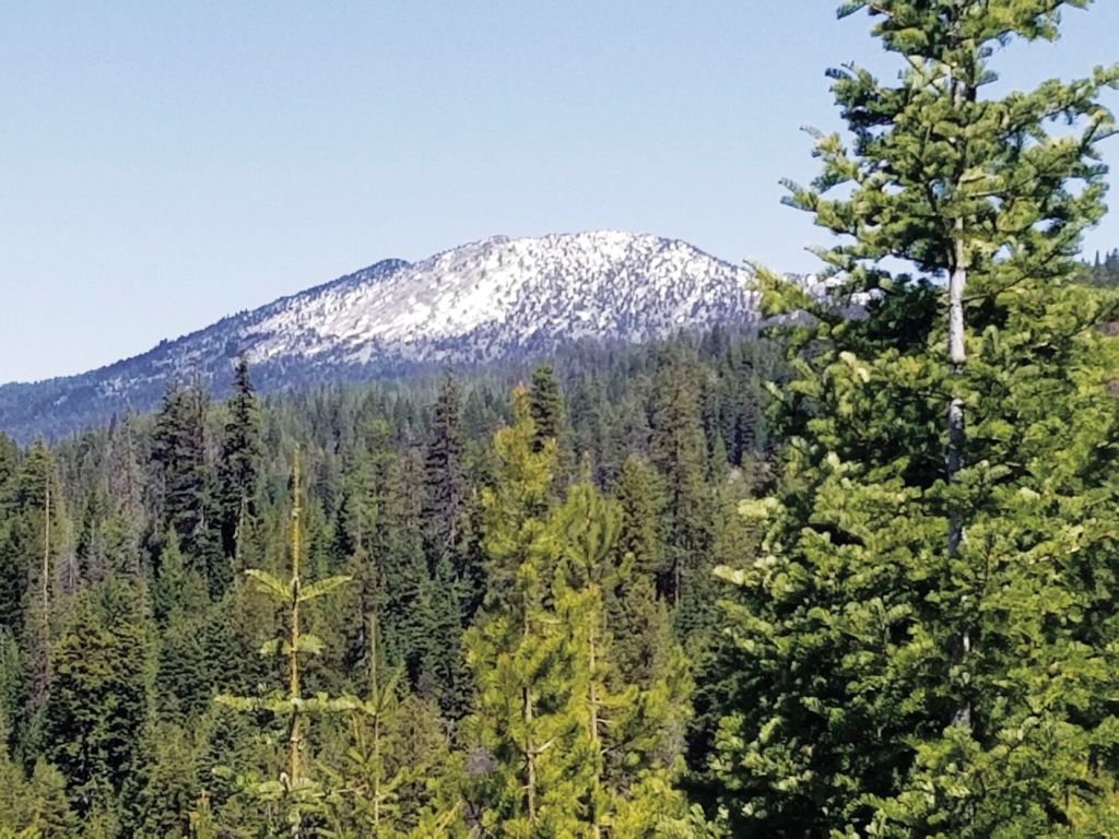
- Mount Ireland, a western extension of the Elkhorn Mountains, is topped by a fire lookout that’s staffed each summer. The mountain, which rises to 8,321 feet, is on the hydrologic divide between the Powder and North Fork John Day rivers, which also serves as the boundary between Baker and Grant counties. The lookout itself is in Grant County, just a few hundred feet or so east of the Baker County line.
Maps fascinate me, and because they do I harbor what’s probably an abnormal interest in boundaries.
Political boundaries in particular.
Physical borders can be compelling too — the Cascade Mountains, for instance, which divide Oregon and Washington into their wet and arid sides, or a great chasm such as Hells Canyon. But these natural boundaries generally are not so distinct, or anyway not so easy to define with specificity, as the lines we draw on maps to separate counties, states and other delineations of human construction.
Of course we often borrow natural features to serve such functions.
Waterways, both great and small, commonly fill this role, creating conspicuous, if rather squiggly, borders.
In our region the Snake River and its reservoirs form the boundary between Oregon and Idaho for more than 100 miles.
(This stretch starts just north of Adrian, in Malheur County. From that point south, in what has always struck me as a curious deviation from cartographic conformity, the Snake for several miles flows wholly within Oregon, this being the only area where it doesn’t form the border. From the spot where the Snake begins as the state border, the boundary to the south is a ruler-straight line that continues to the so-called “triple point” where Oregon, Idaho and Nevada meet — a sort of ersatz, rarely visited version of the famous Four Corners, where New Mexico, Colorado, Utah and Arizona come together.)
The border between Baker and Union counties, meanwhile, is formed for many miles by either the North Powder River or Anthony Creek, two streams that drain from the east slopes of the Elkhorn Mountains.
But the people who made these geographic decisions don’t always rely on rivers.
I find it passing strange, for instance, that the Minam River, the biggest river flowing from the northwest side of the Wallowa Mountains, doesn’t mark the border between Union and Wallowa counties.
Those two counties indeed meet in the Minam River Canyon, but the division is a series of straight lines rather than the meandering river itself.
In many cases when water itself doesn’t conform to a political boundary, natural drainage patterns fill that role.
Geographers, and others interested in such matters, sometimes call such a feature the “hydrologic divide.” Typically ridges or shoulders of mountains, these are elevated country that stands between two creeks or rivers.
As with waterways themselves, hydrologic divides span a spectrum from a minor eminence that separates two trickling tributaries, to America’s most famous such division, the Continental Divide.
The latter, which is marked prominently on many maps and given much attention in the form of roadside signs and scenic vistas — the divide coincides in places with highway passes — is the narrow point on the ground where water flowing west eventually reaches (in theory at least) the Pacific Ocean, and water heading east winds up in the Atlantic (by way of the Gulf of Mexico in some significant cases, including the mighty Mississippi).
In Northeast Oregon, hydrologic divides most often serve as boundaries between hunting units, national forests or ranger districts.
But occasionally these natural features also separate counties.
A notable example is the border between Baker and Grant counties. For more than 30 miles the western boundary of Baker County, and the eastern border of Grant, is defined by the hydrologic divide between the Powder River and the North Fork of the John Day River.
This past Sunday, May 16, I went for a hike with my wife, Lisa, and our son, Max, during which we crossed that divide — and the county line — in the mountains several miles northwest of Sumpter.
Our route was on a forest road with moderate grades and occasional views of the multiple mountain ranges.
It was a fine morning for a hike, the penultimate day of the summery stretch that has since been rudely interrupted by weather more typical of March than May.
Forest Road 900 branches off the Elkhorn Drive Scenic Byway northwest of Sumpter (see “If You Go …” box above).
From the Byway it’s about 2.2 miles, with an elevation gain of 700 feet, to the divide that marks the county boundary. We drove up Road 900 for a little more than a mile, starting our hike near where the road runs beneath the Oregon Trail Electric Cooperative power line that goes to Granite.
The road runs through a classic Blue Mountains mixed-conifer forest. On the warmer, drier south-facing slopes big ponderosa pines share space with grand firs and Douglas-firs, while on the shadier north and east slopes, where snowdrifts defied the balmy air, the stand is a denser, more diverse combination of tamarack, lodgepole and grand fir.
The road switchbacks a couple times before reaching the 5,800-foot crest of the ridge in a wide saddle. This is the sort of remote mountain intersection that always intrigues me because it is such a natural rendezvous spot. I wonder how many gatherings have happened here, how many times hunters have paused on a snowy November day to talk about elk, or firefighters have stopped to spread a map across a pickup truck’s warm hood while searching for a reported plume of smoke.
Another road — the 850 — joins Road 900 here. Road 850 descends for a mile or so to Bull Run Creek and Gold Center, where a pipe spills frigid spring water at a turnout on the Elkhorn Byway.
As we didn’t want to regain several hundred feet of elevation, we opted to stay on Road 900, which is mostly flat as it contours along a slope.
I’m glad we did, not so much for the easier hiking but because of the views from the relatively lofty vantage point. First to appear between gaps in the forest — mostly young lodgepoles that recolonized this area following bark beetle outbreaks and fires decades ago — was shield-shaped Desolation Butte, its fire lookout tower barely discernible.
As the road continued south we had a fine view of Mount Ireland, another summit capped by a fire lookout that’s staffed each summer. Ireland’s lookout, though several miles closer, isn’t visible from this point, though — unlike the thickly forested (if curiously named) Desolation, Mount Ireland’s summit is mostly bare rock, so there was no need to perch its lookout atop a tower to afford the firewatcher an expansive view.
At each bend in the road another range came into sight — the Greenhorns, with the naked pinnacle of serpentine, the actual green horn, standing conspicuous below Vinegar Hill, the range’s apex; then Strawberry Mountain, tallest peak between the Elkhorns and Steens Mountain; and finally a brief glimpse, through a gap in the intervening ridges, of Dixie Butte.
I briefly considered making a loop hike — I generally abhor backtracking — but after a quick look at the map I decided against that option. To get back to the 900 Road junction we’d have had to walk nearly three miles on the shoulder of the Elkhorn Byway. Returning the way we’d come was both shorter and, perhaps more attractive on a day that had warmed into the 70s, much shadier.
The grandest viewpoint turned out to be almost within sight of where we parked. We came round a corner and suddenly the eastern horizon was dominated by the Elkhorns, and in particular Rock Creek Butte, highest in the range at 9,106 feet.
From downtown Sumpter, continue northwest on the Elkhorn Drive Scenic Byway toward Granite for about 4.7 miles to the junction with Forest Road 900. The junction is at a sweeping curve in the byway.
From the byway it’s about 2.2 miles to the top of the ridge, which marks the Baker-Grant county border. The elevation gain is 700 feet. From the border (which is not marked), Road 900 continues for 1.3 miles where it rejoins the Elkhorn Byway. You could do a loop hike, but that would require walking for 2.7 miles on the shoulder of the Byway to get back to the junction with Road 900.