On the trail: The Blues beckon, even when they’re not beautiful
Published 3:00 am Saturday, August 20, 2022
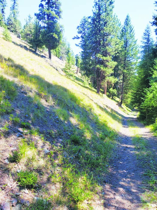
- Forest Road 7300-990 in Buck Gulch, near Sumpter.
Buck Gulch is not beautiful.
Not by the standards of Northeastern Oregon, anyway.
This is a terribly unfair comparison, to be sure.
Competing against nearby natural marvels such as Wallowa Lake and the Elkhorn Mountains and Hells Canyon, Buck Gulch, a minor stream near Sumpter in far western Baker County, is destined to seem drab.
Buck Gulch was neither carved by a great river nor sculpted by glaciers.
A narrow gulch, it yields no grand vistas.
And it’s a placid little brook, particularly in summer.
No waterfalls.
Yet even though Buck Gulch almost certainly will never grace the cover of a calendar or the pages of a coffee table book, it is a pretty wonderful place.
Indeed, on one in the long spell of sullenly hot days that has marked the latter half of this summer, the gulch, with its long stretches of shade, seemed to me the ideal spot for a moderate hike.
And I was reminded, as so often happens while I’m rambling our corner of Oregon, that we’re awfully fortunate to have so many wonderful places to explore.
I picked Buck Gulch for a couple reasons.
It’s convenient, just 32 miles or so from Baker City.
More importantly, with the temperature forecast to go above 90 on Sunday, Aug. 7, I knew, although I had never hiked the gulch, that it would be at least partially shaded.
The hardest part of the trip was finding the road.
Forest Road 7300-990 follows the gulch for most of its length, starting from near where the stream joins McCully Fork, a couple miles west of Sumpter.
I drove right past the road junction along the Sumpter-Granite highway, even though I had looked at a map before leaving and knew the road started just past McCully Fork campground.
When I knew I had gone too far up the grade toward Blue Springs Summit I turned around. My wife, Lisa, saw the turnoff.
It is, I must say, an inconspicuous intersection. The highway — it’s also part of the Elkhorn Drive Scenic Byway, Forest Road 73 — is about 100 feet higher than the stream, and Road 990 plunges down a steep slope. Due to the terrain, the road sign isn’t visible from the highway.
There’s a pullout on the south side of the highway a couple hundred feet east of the junction, and I parked there.
Other than the first short section, the road has comparatively gentle grades as it follows Buck Gulch upstream. Just a tenth of a mile or so from the highway, a rivulet of frigid water flows across Road 990. It’s fed by a spring beside the road.
We stopped there so my son, Max, who’s 11, could soak the towel he recently acquired. The fabric, or so the package it came in promised, would, once saturated, remain cool for many hours. Max draped the clammy brown thing around his neck, a sort of summer scarf designed to cool rather than warm.
There is nothing outstanding about Buck Gulch, as I mentioned.
It is not notably different from any of many dozens of streams that drain the Blue Mountains, its fringe of alder and red osier dogwood instantly familiar.
The road, which is open to vehicles, although better suited to four-wheel drives or ATVs, is typical of its type as well — narrow, but without deep ruts or boulders or other significant impediments.
We hiked about a mile and a half, gaining around 500 feet of elevation. It was, as I had hoped, a fine place for a walk on a hot and sunny day. Buck Gulch is narrow enough, and the forest dense enough, that sunlight is, if not blocked altogether, then at least nicely filtered in most places.
And although it was warm even in the shade, the road never strays far from the stream — the topography doesn’t allow otherwise — and we paused a few times to let Max refresh his nifty new towel. I wrapped it around my neck for a while and it was as advertised, blessedly chilly.
For almost the entire hike we saw no one.
Although the road is never more than half a mile or so from the comparatively well-traveled highway, once we had gone a quarter mile or so I never heard the hum of engines on the pavement above.
We turned around at the Buck Gulch mine, where a travel trailer was parked and a pickup truck, laden with firewood, was just leaving.
(The truck took a different route, a wider road that connects to the highway near Blue Springs, on the divide at the boundary between Baker and Grant counties.)
As with every gulch around Sumpter, gold miners, dating to the 19th century, gave Buck Gulch a thorough going over.
We passed the remains of a log cabin and another structure, possibly a small mill. Although all the land along the road and in the gulch is public, part of the Wallowa-Whitman National Forest, there are active mining claims throughout, so it’s illegal to pan for gold or do any other sort of prospecting.
I must have driven past Buck Gulch close to a hundred times over the past 30 years or so — you can’t avoid it if you’re driving from Sumpter to Granite and points beyond.
Yet it wasn’t until August 2022 that I actually visited the gulch and hiked its road.
I find this rather amazing, and deeply gratifying.
Not every hike can be an epic, multi-day backpacking trip through the Eagle Cap Wilderness or some other landscape that, unlike Buck Gulch, leads photographers to use their memory card’s every megabyte and prompts visitors with no literary pretensions to discover a latent affinity for poetry.
But Buck Gulch, and the dozens of places like it in the Blues, enrich our region too.
I hope never to become so complacent, so accustomed to the grandeur around us, that I fail to appreciate the simple pleasure of a shady road beside a cool mountain stream.


