Double Creek, Eagle Cap Wilderness fires see significant growth
Published 10:25 am Sunday, September 4, 2022
- The Double Creek Fire started in late August after lightning strikes and grew to become the largest wildfire in Oregon. The U.S. Forest Service is distributing $1 billion to communities to help protect them from wildfire, but many communities don't know about the funding.
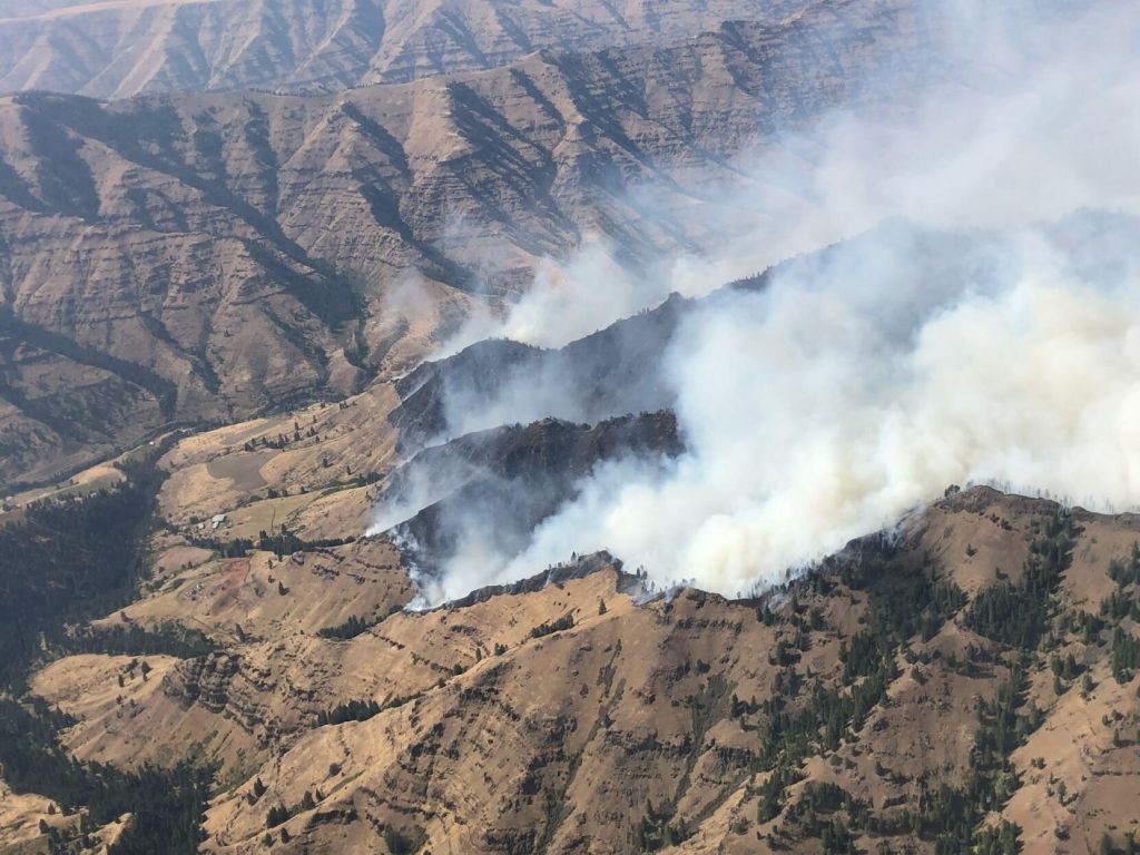
ENTERPRISE — There was significant fire growth on the Double Creek and Eagle Cap Wilderness Fires on Saturday, Sept. 3, as a result of strong winds, hot temperatures and extremely dry conditions.
According to the Sunday, Sept. 4, briefing, the Oregon Office of the State Fire Marshal Green Team was mobilized on Sept. 3 and will be in unified command with Pacific Northwest Team 2 for the Double Creek Fire, which is burning 10 miles southeast of Imnaha.
The lightning-caused Double Creek Fire has burned more than 37,500 acres and is 0% contained. There are 232 personnel assigned to combat the blaze. The fire experienced significant growth Sept. 3 to the north along Grizzly Ridge and east toward the Snake River. To the south, the fire backed down the Granny Creek Drainage toward Freezeout Road. Firefighters were engaged in protecting private lands and infrastructure along the Imnaha River corridor on Sept. 3 but were pushed to areas of refuge on several occasions due to intense and erratic fire behavior.
Firefighters and aviation resources responded to evacuate several hunting parties that had been isolated due to the large fire growth. Despite a forecast for lighter winds on Sept. 4, warm and dry conditions will result in active fire behavior on the east and west slopes of Grizzly Ridge and additional fire spread to the north. Fire will continue backing downslope toward the Imnaha River in the Schleur, Adams, College, Double, and Blackmore creeks.
Firefighters will be working Sept. 4 with task forces from the Oregon Office of the State Fire Marshal to protect property and infrastructure along the Upper Imnaha Road.
Evacuations remain in place for the Double Creek Fire. Hat Point and Freezeout roads are under a Level 3 “Go Now” evacuation. The Hat Point Road is also closed due to the fire activity. Imnaha River Road, from Rippleton Creek to the Imnaha Grange is under a Level 2 “Get Set” evacuation. Imnaha River Road, from the town of Imnaha to Rippleton Creek and from the Imnaha Grange to the Pallette Ranch including Imnaha River Woods is under a Level 1 “Be Ready” evacuation.
Eagle Cap Wilderness Fires
The Sturgill Fire has burned 11,600 acres and is 0% contained. There are 32 personnel assigned to the blaze, which is burning 15 miles southwest of Enterprise.
The Blacktooth Wildland Fire Module and Eagle Cap WFM started structure protection assessments for private inholdings along the Minam River when the Sturgill Fire made a significant push north past Chaparral Creek on Sept. 3. As of the evening of Sept. 3, the fire had not moved west of Minam River.
On Sept. 4, firefighters will focus their efforts on structure protection to the west of the fire.
The Nebo Fire, which is burning 21 miles southeast of Enterprise near Mount Nebo, has burned 6,926 acres and is 0% contained. There are 33 personnel assigned to fight the fire.
The fire saw large growth on Sept. 3, crossing Big Sheep Creek and spreading over the top of Wing Ridge to the north.
The fire burned outside the Eagle Cap Wilderness toward the 39 Road and 200 Road.
With continued fire activity expected in the Lick Creek area toward the Lick Creek Campground, firefighters spent Sept. 3 clearing the public out of the Lick Creek Campground and ensuring that additional public stayed out of the area.
Firefighters will work Sept. 4 along the 39 Road to the 200 Road to begin building a control line to the east.
The Goat Mountain 2 Fire has burned 95 acres and is 0% contained.
There was no significant growth on the Goat Mountain 2 Fire on Sept. 3. The fire will continue to be monitored and firefighters will take action to suppress the fire in Lostine Canyon if needed.
SALEM — The Oregon Department of Environmental Quality issued an air quality advisory Saturday, Sept. 3, for Klamath, Lake, Deschutes and Wallow counties, due to smoke from multiple fires, including the Double Creek, Cedar Creek and Rum Creek fires.
DEQ expects intermittent moderate to unhealthy smoke in Central and Northeastern Oregon through at least Tuesday, Sept. 6, due to localized impacts from nearby fires. This includes Baker, eastern Grant, Malheur, northern Harney, eastern Lane and southern Douglas counties.
— The Observer