More resources arrive to fight Double Creek Fire
Published 9:04 am Monday, September 5, 2022
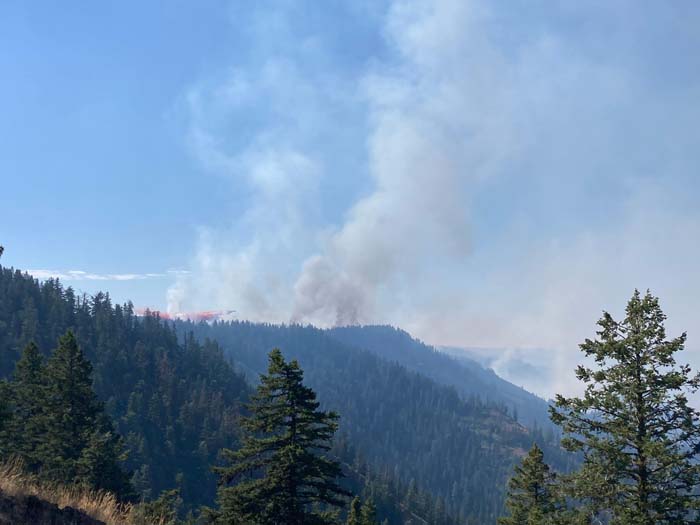
- A large air tanker provides active fire suppression on the Double Creek Fire in Wallowa County on Wednesday, Aug. 31, 2022.
ENTERPRISE — Additional resources continued to arrive on Sunday, Sept. 4, including task forces from the Oregon Office of the State Fire Marshal, to help battle the both the Double Creek and Eagle Cap Wilderness fires in Wallowa County.
The Double Creek Fire is the largest wildfire burning in Oregon.
The fire has now burned 43,668 acres, according to the Sept. 5 update, up from the more than 37,800 acres reported on Sept. 4. The blaze is still zero percent contained, and there are more than 400 personnel assigned to fight the fire.
Oregon Gov. Kate Brown invoked the Emergency Conflagration Act on Sept. 3 in response to the Double Creek Fire.
Strong winds, hot temperatures and humidity that dipped into single digits in places Sept. 3 also enabled two lighting-caused fires in the Eagle Cap Wilderness to grow substantially.
According to a press release from the Type 1 overhead team that’s managing the Double Creek and the wilderness fires, task forces from the State Fire Marshal’s office initiated structure protection on the Double Creek Fire, cleared brush and increased defensible space around homes along the Freezeout and Imnaha roads.
Firefighters secured a private inholding (Section 36) along Grizzly Ridge between Buck Point and Pumpkin Creek. Dozers cleared vegetation along the power line in the Imnaha River corridor. All the known hunting parties were safely evacuated from the area.
According to a release from the governor’s office, the declaration allows the Office of the State Fire Marshal to take unified command immediately. Wallowa County Sheriff Joel Fish has issued Level 3, Level 2 and Level 1 evacuation orders for homes near the fire.
Firefighters on Sept. 5 were scouting for additional options on the northern and southern portions of the fire. Crews will mop up and patrol around structures along Freezeout Road and north along the Upper Imnaha Road. Firing operations will continue along the Upper Imnaha Road to secure the fire backing down drainages to the east. State Fire Marshal task forces will continue to assist with structure protection along the Imnaha Road and ensuring the protection of life and property in the community of Imnaha.
Brown’s declaration cleared the way for the State Fire Marshal to mobilize firefighters and equipment to assist local resources battling the fire and further support a coordinated response.
Local mutual aid and federal resources are on scene working to slow the fire’s progress. An OSFM Incident Management Team assumed unified command Sept. 3 with federal partners. OSFM will bring in four additional task forces through the Oregon Fire Mutual Aid System from Lane, Clatsop, Washington and Yamhill counties to assist in the response.
The Double Creek Fire is a “full suppression” blaze, which means officials are trying to douse it as soon as possible.
The Wallowa County Sheriff’s Office on Sept. 4 modified the evacuation levels for the Double Creek Fire. A Level 3 “Go Now” is in effect for the town of Imnaha and south to Freezeout Road. The Upper Imnaha Road, Hat Point Road and Wallowa Mountain Loop Road (Forest Service Road 39) are closed. A Level 2 “Get Set” is in effect for the area from the town of Imnaha north to Fence Creek, including the lands east toward Lightning Creek. A Level 1 “Be Ready” is in effect from Freezeout south to the Pallette Ranch and Imnaha River Woods.
Eagle Cap Wilderness fires
The Sturgill and Nebo fires in the Eagle Cap Wilderness, by contrast, are “managed” fires. That means officials are using a variety of tactics, monitoring the fires in some areas but taking actions, such as having helicopters drop water and dispatching firefighters on the ground, to try to limit the fires’ spread in certain directions.
The Sturgill Fire has burned 12,703 acres and is zero percent contained, according to the Sept. 5 update. There are 31 personnel assigned to fight the fire, which is burning 15 miles southwest of Enterprise.
Firefighters worked Sept. 4 on structure protection for residences in the area. The Wildland Fire Modules will continue to implement structure protection for private inholdings along the Minam River on Sept. 5. Smokejumpers will assist with structure protection efforts.
The Nebo Fire, which is burning 21 miles southeast of Enterprise near Mount Nebo, has burned 7,277 acres and is zero percent contained. There are 50 personnel assigned to fight the fire.
Firefighters spent Sept. 4 building a control line along the Wallowa Mountain Loop Road (Forest Service Road 39) to the 200 Road. On Sept. 5, additional resources will be assigned to assist with fireline construction and initiate firing operations along the Wallowa Mountain Loop (Forest Service Road 39) and 200 roads.
Crews and heavy equipment will be used to keep the fire west of the road. Firefighters will also implement structure protection for Forest Service infrastructure, including the Lick Creek Campground, as the fire continues to move to the north and east.
Both the Sturgill and Nebo fires have surpassed the 2019 Granite Gulch Fire as the biggest in the Eagle Cap Wilderness since the Wallowa-Whitman National Forest instituted a policy allowing lightning fires to burn naturally. The Granite Gulch Fire burned about 5,500 acres in August and September 2019.
There are two other fires burning in the Eagle Caps, also sparked by lightning Aug. 22 or 23. The Goat Mountain Fire 1 is not active, according to fire managers. The Goat Mountain 2 Fire is about 95 acres, but, unlike the Sturgill and Nebo fires, it did not grow substantially over the weekend.