HIGHWAY 82 – ROAD TO THE PROMISED LAND
Published 12:00 am Monday, April 30, 2007
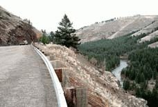
- From Minam Summit at 3,528 feet, Highway 82 begins its six-mile descent to the Minam River. (Photo/ROCHELLE DANIELSON).
First of two parts
La Grande to Minam Summit to Wallowa Lake
Rochelle Danielson
For The Observer
Ever since the days when early settlers in the Grande Ronde and Wallowa valleys traded their painted wagons for a parcel of land, Oregon’s pristine northeast corner has enchanted travelers.
Driving anywhere along Highway 82 between
La Grande and Wallowa Lake always enchants me whether I’m gazing at the rich farmland that stretches across the Grande Ronde Valley, taking a break at the Imbler Country Market for a soda pop and rope of "famous pepperoni," or surveying the rugged landscape of the Wallowa Mountains.
Not until 1872 was there a road linking the two valleys. Trappers, explorers and surveyors followed trails used by the Indians. Soon wagon tracks mingled with the trail routes. Homesteaders built a temporary road as far as Cricket Flat, but for the few who pressed on, the Nez Perce trail was their only route.
And then like charms on a bracelet, the Grande Ronde became linked to the Wallowa Valley through the ingeniousness of Captain A.C. Smith, known as the Daniel Boone of the Wallowas. His building of a road down the Wallowa Hill, a toll bridge and road up and over Smith Mountain enabled homesteaders to reach the promised land they’d only heard glowing stories about.
The first pioneer road traveled through Union, once the county seat, passed Hendershot Point, journeyed the Lower Cove Road along the foothills beneath Mount Harris and crossed over the pass into Indian Creek, thus avoiding any river crossing. From Indian Creek the road took a northeastern path on Clark Creek direct to Elk Flat, located near Stubblefield Mountain.
A second, or later traveled road, from La Grande probably followed the western hills along the timberline beneath Mount Emily and the Blues, near the Mount Glen settlement. From Summerville the road curled along the base of Pumpkin Ridge to Rinehart Road, crossed the bridge over the Grande Ronde River and continued the same route as the earlier pioneer road. About this time, in Indian Valley, a bridge at Fishtrap ford was built.
From 1872 and on, covered wagons, freight teams with bells, stage coaches, buck boards and carriages traveled the roadbeds. The mode of travel began to change as railroad tracks were extended from Elgin to the Wallowas in 1908. The first automobile drove through the canyon in 1907.
In 1917, the road was designated as a primary state highway OR82, or the Wallowa Lake Highway. The state slogan at that time was, "Get Oregon out of the Mud."
Road improvements were made from La Grande to Joseph in the 1920s, and a fourth road was built on the Minam Grade in1921-22.
In those years the road surface was constructed of gravel and soil. Surface improvements were conducted in1925 and again "reconstructed" in sections in the mid-1930s. The roadway received hot mix paving in the 1950s, and again in the 1970s.
Now, motorists drive the paved two-laner with ease. It is comfortably wide, well maintained and clearly marked, including passing lanes and turnouts. The 60 mph speed limit requires an attitude adjustment after cruisin’ the interstate but just remember there’ll be no pedal-to-the-metal on this road.
The 76-mile distance to Wallowa Lake can be covered in under two hours, but why hurry? The drive is best enjoyed at a leisurely pace.
From Island City to Joseph, the highway is part of the Hells Canyon Scenic Byway. It was given designation as an All-American Road in 2000.
So, leave the freeway. Let this highway enhance your soul. Breath in its diverse surroundings, and too, pick up some historical tidbits.
Bring along with you the words of the pioneers upon their first visit to the Grande Ronde: "… a beautiful fertile valley that stretches 20 miles, and is surrounded by high mountains with good grass, water and an abundance of wood."
Although thousands of emigrants, following the Oregon Trail, passed through the valley on their way farther west, La Grande did not become a settlement until 1861, when gold was discovered in "them thar" Oregon hills. A few cabins were built in what is now known as the Mount Glenn District, and given the name Browns Fort. Later, a Frenchman used the french phrase to describe his delight with the view, thus inspiring the name, La Grande.
As you begin your sight-seeing journey it’s difficult to tell where the La Grande boundary ends and Island City begins not so when it was an island.
A business center for flour production in the 1860s, Island City today boasts yep, you guessed it a Wal-Mart Super Center. But close by, a 9-hole golf course is sure to soothe life’s shopping woes.
One final traffic light and you’re free to roam about the country.
Toward the outskirts of town check out valley industry Boise Particleboard, Hexion Specialty Chemical and Fleetwood Trailers juxtaposed against an agricultural backdrop in fields of grain, plowed earth and seeded grasses.
Ten miles across the valley, Cove once known as Forest Cove, and settled in 1862 nestles against the base of Mount Fanny. This town brings to mind cherry orchards, a swimming pool and the road to Moss Springs and the Eagle Cap Wilderness. Let’s not forget the winery.
At Alicel, a granary stands by the railroad tracks, a sawmill falls by the wayside and a highway road sign points out a business community that lived in the year 1890. Alicel was given its name by Charles Ladd, a local resident, in honor of his wife Alice.
Driving five miles farther, surrounded by the rich tilled soil, you can tell that farmers took to heart the journal writings of emigrant John C. Fremont: "… This is a place one of the few we have seen in our journey so far where a farmer would delight himself to establish."
The highway cuts through the heart of Imbler with its quiet neighborhoods. Founded in 1891 following the completion of the Union Pacific Railroad line from La Grande to Elgin, Imbler flourished. Jesse Imbler’s forethought in platting his ground to build the city resulted in wider streets, including Main and Railroad Avenue.
On northward toward Elgin the pavement continues to run parallel to the railroad tracks. To the left, a mint field lays in wait for an August harvest. Straight ahead Pumpkin Ridge, with cultivated fields covering its slopes, resembles the makins’ of a crazy quilt.
Summerville, five miles to the west, is not visible from the highway, but during the late 1860s played an important role as a supply center. This town boasted a bank, a brewery, a blacksmith, a butcher shop and much more.
Today, the highway leaves the northern Grande Ronde Valley once covered in orchards and descends Hamburger Hill into Elgin, first called Indian Valley. The story goes that the postmaster when looking for a name for the post office overheard his niece and nephew singing about the wreck of the steamer, Lady Elgin, and he named the town after the song.
In earlier times sawmills seemed to come and go, but Elgin proudly claims a Boise plywood plant and stud mill. Also, the 1912 Opera House & Museum reach high notes with its audience as does C’Zer’s Drive-In with its "burger and fries."
Crossing the Grande Ronde River Bridge (the old bridge site is100 yards north), ascending Fishtrap Hill and cruising across the rolling plains of Cricket Flat is a pleasant drive. This span of pavement can be a stickler in winter as blowing snow reeks havoc, but was even more of a pain for settlers in the muddy aftermath of a rain storm.
Snow storms will come again, but let’s hope the mud and crickets will not.
Cricket Flat Grange and the Old Fort Barn have disappeared with time and weather, but traces of the road remain along this stretch. Also a water fountain, next to the road near the old Parson Place (later McClures) continues to overflow a trough as it did when homesteaders brought their empty barrels to the spring.
To the south of the present Hindman Road, Pike’s Peak, a natural mound, stands tall. In the minds of the Grande Ronde settlers the cinder cone-shaped peak signaled the end of the road. This landmark got its name from Pike Ward, a short-time homesteader to the area.
Life on Cricket Flat was not all work.
"Before the railroad came to Elgin in 1890," says Dale Victor of Wallowa, "families on Smith Mountain would gather the kids and travel to the Cricket Flat Grange to dance the night away, then return home Sunday."
A mile before reaching the Minam Grade, a graveled road to the right leads to Pine Grove, where the old school building remains and where a white steeple church once graced a pine setting often time painted by artists.
From Minam summit at 3,528 feet, Highway 82 begins its 6-mile descent to the Minam River. On any given good-weather day or night, the drive to the canyon floor can safely be driven in 10 minutes.
Not so for those early settlers descending the pioneer road on the Wallowa Hill, north of the present grade. Though two miles shorter in distance, this notorious piece of real estate represented a slow, treacherous traverse, or a walk down the Indian trail. Homesteaders approached with trepidation.
Imagine their concerns.
Highway 82 continues. Enchantment awaits.
Next Monday: Minam Hill to Wallowa Lake
References:
"The Blue Mountains and the Oregon Trail,” by John W. Evans
"Gateway to the Wallowas,” Irene Locke Barklow
"History of State Highways in Oregon”
"History of Union County,” Bernal D. Hug
Of Interest:
? The Sand Ridge Road could have been a pre-pioneer road.
? Dale Victor is the son of Clara and Alva and grandson of Frank and Laura Victor. The Frank Victors were caretakers of the toll bridge and hotel at Minam.