Fire danger beginning to creep higher
Published 11:00 am Tuesday, July 19, 2022
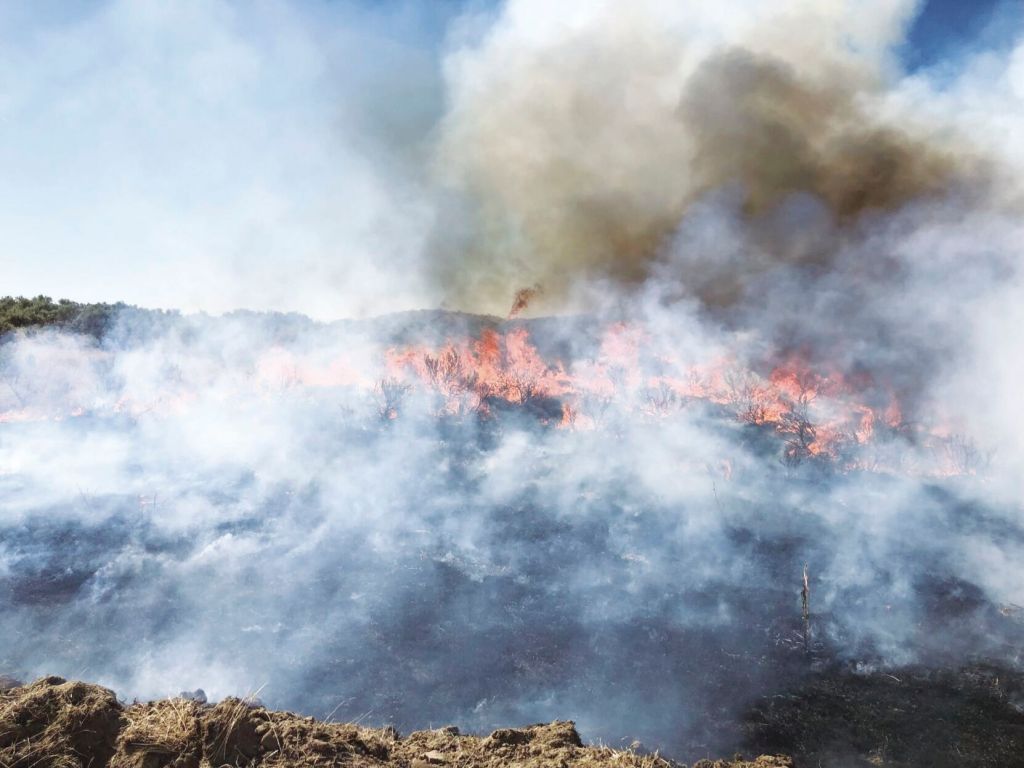
- The Willowcreek Fire burns in northern Malheur County on Wednesday, June 29, 2022.
BAKER CITY — The wildfire season has been pretty tranquil in Northeastern Oregon, but Al Crouch and Nathan Goodrich are beginning to detect the potential for boisterous days to come.
They see it in the grass, nourished by plentiful spring rain but now curing into tinder beneath the July sun.
And in the heat that has finally arrived, pushing temperatures to triple digits at lower elevations, and humidity levels below 20%.
“It’s definitely drying out,” Goodrich, fire staff officer for the Wallowa-Whitman National Forest, said. “Things have changed quite a bit in the last two weeks.”
Crouch, the fire mitigation specialist for the Bureau of Land Management’s Vale District, concurred with his fellow federal fire manager.
“The drying is happening fast,” Crouch said.
That’s especially so in Baker County and points south, he said.
The lush crop of grass, including invasive cheatgrass, that grew this spring has already dried in much of Malheur County, and the trend is moving north, Crouch said.
Conditions are still comparatively damp, and the fire danger somewhat lower, to the north, he said.
After the soggy spring, the Baker City Airport has been relatively parched, measuring just 0.05 of an inch of rain since June 6. Thunderstorms that doused other parts of the region mostly missed Baker City.
Meacham, by contrast, has had 3.12 inches of rain during that span, most of it coming from a couple of June cloudbursts.
The Eastern Oregon Regional Airport in Pendleton has recorded 1.33 inches since June 6.
The Willowcreek Fire, which started on private property north of Vale on June 28, rapidly spread to about 40,000 acres, propelled by gusty winds on a day when temperatures reached 100 degrees in north Malheur County.
That fire shows the potential for fast-moving fires given a combustible combination of weather conditions, Crouch said.
Yet that blaze, which is still under investigation, is also a conspicuous anomaly.
The Blue Mountain Interagency Dispatch Center at the Union County Airport, which oversees much of Northeastern Oregon — although not Malheur County — has recorded just 17 fires this year, which burned a scant 2.7 acres.
Although the fire danger rating is high on BLM ground, Crouch noted that the agency has yet to impose restrictions on campfires. Nor has the Forest Service.
That’s in sharp contrast to 2021, when a dry spring resulted in an abnormally early start to fire season and to its associated regulations on public lands in Northeastern Oregon.
This year, Crouch said, “those late spring rains put a lot of moisture in the ground and greened things up.”
Both Crouch and Goodrich agree that the 2022 fire season is more typical for the region, in that the fire danger, rather than rising to extreme levels even before the summer solstice, is beginning to rise only as July nears its middle.
“It feels more like a typical season from the 1990s or early 2000s,” Goodrich said.
Between 1999 and 2010, about 80% of the wildfires on the Wallowa-Whitman started between July 15 and Aug. 15, he said.
Although he noted that statistics haven’t been updated for the past five years, he suspects there have been more fires in the first half of July than in the past, and that the fire season has extended a bit later into late summer and early fall.
Fire danger remains moderate in most of Northeastern Oregon. The energy release component, an estimate of how fast a fire would spread based on moisture levels in fuels, is below average in each of the six geographic zones that the Blue Mountain Interagency Dispatch Center monitors.
The numbers, which briefly went above average in late June before dropping again due to widespread rain in early July, have been rising again for the past several days.
Goodrich said the few lightning-sparked fires reported earlier in July burned sluggishly, generally not spreading beyond the drip line of the tree that was struck by lightning. He expects fires through the rest of the summer will be more energetic.
In addition to the increasing fire danger, Goodrich and Crouch are tracking weather patterns that bring thunderstorms to the region.
That’s a crucial factor, since lightning in most years ignites about 80% of the fires on public land. (The percentage is generally lower on private land, where human-caused fires are more common.)
In the meantime, Crouch said the grasses and sagebrush that fed the Willowcreek Fire will continue to be a source of easily burned fuel.
“Our fuel loading in the grasses is much higher than it was last year,” he said.
Lightning from a series of storms that started Tuesday afternoon, July 12, and continued into Wednesday morning ignited several small fires in Northeastern Oregon.
As of Wednesday morning, the Blue Mountain Interagency Dispatch Center — bmidc.org — in La Grande was reporting these blazes:
• Spool Cart campground area, 15 miles southwest of La Grande, 0.1 acre
• Thief Valley Area east of North Powder, 0.25 acre
• Flagstaff Butte area, northeast of Baker City, no size listed
• Sumpter area, no size listed
• Granite area, no size listed
• Twin Mountain area northwest of Haines, 0.1 acre


