EXPLORING CHRISTMAS VALLEY
Published 12:00 am Friday, September 24, 2004
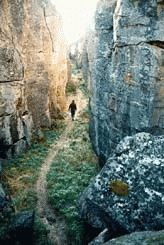
- A hiker explores the path that leads through Crack-in-the-Ground, a two-mile long fissure created more than 1,100 years ago. (Photos/Mark Highberger).
By Mark Highberger
For The Observer
It’s the home of a lost forest and a cracked ground, of lakes without water and sand dunes without ocean shores. And anyone who travels through this land of curiosities and contradictions in southeast Oregon’s Christmas Valley will find a story of how the earth has changed since the time of erupting volcanoes.
Northern Lake County is a land of hayfields and sage flats, where the pumps and pipes of circle irrigation systems struggle to hold back the desert. Past the pavement, rutted roads and swirling dust mark the entrance into the backcountry of the Christmas Valley basin and hills. Along these backroads that stretch east and north from the town of Christmas Valley, you’ll find at least four chapters of a unique history.
FOSSIL LAKE
The journey begins some 16 miles northeast of town in an area that today is dry, dusty desert. But 10,000 years ago, Fossil Lake covered the entire basin now holding both Fort Rock and Christmas Valley. In those days, mammoths, camels, and flamingos wandered the lake’s shores while fish swam in its depths.
The fossils found in this area nowsome dating back two-million yearsare rare, the Bureau of Land Management (BLM) says, because they come from andamp;quot;small mammals not normally found in such volume and variety.andamp;quot;
Although collecting fossils is against federal law, you can still walk within the fenced area enclosing some 6,500 acres of the old lake. But be warned: A restricted budget has resulted in spotty maintenance, so this area may be poorly marked even though it’s adjacent to the road.
SAND DUNES
When Mount Mazama erupted more than 7,000 years ago, some of its ash and pumice blew into the Christmas Valley basin. The result is a rolling stretch of wind-blown sand that covers 16,000 acres and reaches 60 feet in height. The BLM calls it andamp;quot;the largest inland moving sand dune system in the Pacific Northwest.andamp;quot;
The Christmas Valley Chamber of Commerce, however, advertises it as andamp;quot;some of the best ATV (All Terrain Vehicle) riding in central Oregon.andamp;quot; As a result, you’ll find the whining motors and spinning tires of dune buggies and motorcycles almost everywhere along this stretch of road.
andamp;quot;This area sees only about 8,000 visitors per year,andamp;quot; says a man familiar with the area. andamp;quot;But it seems like every one of them is driving an off-road vehicle.andamp;quot;
LOST FOREST
With the sand humped to the south and the sagebrush everywhere else, the road gets rougher as you travel deeper into the desert, until in the distance emerges a line of trees, a forest rising from the desert, its pines standing above the sage. This is the beginning of the Lost Forest.
Two sentry pines mark the entrance to this forest where ponderosa pinesalong with the neighboring juniper, sagebrush, and bitterbrushmake up almost 6,000 acres of the 9,000-acre complex known as the Lost Forest Research Natural Area, which was established in 1972.
Actually, the forest here isn’t so much lost as misplaced, for it stands in the middle of a desert where pine trees are supposed to die instead of thrive. Located 40 miles from the nearest pine forest neighbor in a land where summer temperatures can exceed 100 degrees, these pines receive less than 10 inches of the minimum 14 inches of precipitation they require in a year. As a result, don’t expect the towering, orange-bellied pines so common through much of central Oregon.
andamp;quot;The trees aren’t that spectacular until you compare it to the desert you’ve been driving through,andamp;quot; says a woman along the road with her Labrador retriever. andamp;quot;In that way, the forest is a curiosity.andamp;quot;
It’s also durable. By the first decade of the 20th century, more than 100 homesteads in the area depended on the Lost Forest pines for building, fencing, and heating. Even though droughts drove out most of the homesteaders by the 1920s, the years after World War II saw the coming of timber companies that began to log the forest.
For more than 25 years, however, Lost Forest’s designation as a Research Natural Area has stopped logging and protected the trees, and the presence of young pines means the forest is regenerating itself, providing a home to jackrabbits, mule deer, pronghorns, and even elk.
CRACK-IN-THE- GROUND
North of the town of Christmas Valley, a washboard road divides the land: sage on one side, hay on the other, with quail and jackrabbits swapping sides as they see fit. In the distance, a juniper-spotted rim marks the climb out of the basin and the way into volcanic rubble still watched over by the four cinder cones that created it.
If you make the drive when the morning is bright and clean, the early chill carries the scent of juniper and sage, the whistle and chirp of birds. At the top of the rim, the road grows smoother, the sky bluer as you wind your way past bluebirds and robins that dip and flutter from roadside fence posts and juniper trees, seemingly leading you to the parking area that marks the entry to Crack-in-the-Ground.
From here, a quarter-mile walk takes you to a jumble of rocks with the smell of a cellar. This is the Crack, created more than 1,100 years ago with the eruption of the four craters to the north. When the ooze and spew of lava released enough pressure underground to make a nearby chunk of land collapse, it left an open fissure approximately two miles long and as much as 70 feet deep. Through this fissure now runs a 400-yard trail that shows you what happens when the earth cracks.
Down into the shadows the trail descends, past rocks and through crevices that can wedge you as tight as an Edgar Allan Poe crypt.
andamp;quot;It feels so prehistoric,andamp;quot; says a woman along the trail with her Labrador retriever (same woman, same dog as were wandering the Lost Forest). andamp;quot;You almost expect to see Raquel Welch dressed in a fur bikini.andamp;quot;
Although you won’t see Raquel as you walk the trail and scramble over its boulders, you will see signs of wildlife (deer droppings) as well as modern life (graffiti scrawls and beer cans). Above, rocks that have toppled from the walls over the last 10 centuries squeeze themselves into a stony ceiling.
If, however, you prefer rocks beneath your feet instead of over your head, you’ll be happy to know that the trail plunges and rises, plunges and rises, so whenever you pop into the open you can stay on top, exploring the Crack from ground level, walking the makeshift trails that line the edges of the fissure.
And here in the daylight of the old lake’s basin, you’ll find always the sound of birds, always the scent of sage, always the sense of a land’s history even older than the fossils, the forests, and the fissures it holds.


