MOUNT HOOD LOOP ROAD
Published 12:00 am Friday, August 18, 2006
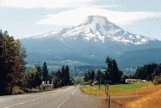
- The 40-mile-long Mount Hood Loop, shown here near the community of Mount Hood, connects Oregon's largest river with its highest mountain. (Photo / MARK HIGHBERGER).
– Mark Highberger
– For The Observer
Stretched between Oregon’s largest river and its highest mountain is a sloped land of orchards and glaciers, of apples and ice. And it’s all connected by a short road that cuts a deep path through both the scenery and the history of the region.
Only 40 miles long, the most significant segment of the Mount Hood Loop road Highway 35 begins at the Columbia River town of Hood River, climbs through the Hood River Valley, and finally merges with Highway 26 on the slopes of Mount Hood. The andamp;quot;Loopandamp;quot; in its name comes from the link it provides in a chain of highways that circles the mountain. Highway 26 continues on to Portland. There Interstate 84 or the far more scenic Historic Columbia River Highway leads back to Hood River.
andamp;quot;The Loop is in fact an arm of the scenic highway along the river,andamp;quot; newspaperman and mountaineer Fred McNeil wrote in 1937, andamp;quot;reaching out to enfold the mountain in the cluster of charms that for years made this road one of the most interesting on the globe.andamp;quot;
But six decades later, with Highways 26 and 84 each shuttling four lanes of traffic between eastern and western Oregon, it’s the Hood River link that best retains its andamp;quot;cluster of charms.andamp;quot;
To get a feel for the valley before you tackle the road, drive first to Hood River’s Panorama Point, a county park just two miles outside town, along a route that climbs steeply through oak and pine before ending at a hilltop overlook. From here the valley sprawls south toward the mountain, more than 300 square miles containing not only the orchards that make this the fruit bowl of Oregon, but also the ridges and rivers that are the reasons that some thought it was impossible to ever build the road. Once you begin your journey along the Loop, that belief may seem to make sense.
The road begins by winding uphill past rows of apple and pear trees, climbing high above Hood River, which was once called Dog River to commemorate a group of starving pioneers who survived in this area by eating their pets. And it was a combination of pioneer spirit though not necessarily their diet and free enterprise that resulted in the area’s first roads.
Sam Barlow started it all. After he blazed an 1845 trail around Hood’s south slope to connect The Dalles with the Willamette Valley, he built gates and then charged tolls to those who followed. Although an 1852 issue of The Oregonian advertised that a road had been cleared from andamp;quot;Dog River to the ferryandamp;quot; on the Columbia River, the Barlow Road remained the only overland route past the mountain, and Hood River’s businesses remained isolated from the state’s population center.
The first attempt to solve this problem came in 1859. That’s when a Capt. Albert Walker started building a road that was to run up West Fork Hood River, around the mountain and down to the Willamette Valley. But the captain ran out of road before he ran out of country, and the project sputtered and died.
Because the first miles of today’s road rolls past gas stations and grocery stores and fruit stands, past orchards lined with smoking smudge pots and turning propellers, you might wonder what all the fuss was about. But continue beyond where clear-cut forests are planted to orchards, the bare hilltops fringed with firs to look like mountainous male-pattern baldness, and you’ll come to a highway viewpoint that lies almost due east of where West Fork joins the main stem.
From here look southwest toward Middle Mountain and Blue Ridge. You’ll see the kind of country the captain tried to carve his way through. So rugged is this land that it took decades more to breach it. And it was another shot of pioneer capitalism that did it.
This part of the road’s story begins soon after you leave the viewpoint and pass through the community of Mount Hood and into the Upper Hood River Valley. Here is where the mountain stares you down and fills the sky, where the forests seem to fade and the clouds to cower. After all, this is a muscular mountain of bulging base and rippling ridges, whose rock-hard glare says don’t even think about putting a road here. Nevertheless, a rough road reached this area by the early 1880s, though the country beyond was thought to be an impenetrable wilderness.
That wilderness, however, cracked open in the summer of 1883, when a group of valley residents began trudging up the mountain, burning trees and underbrush to blaze a charred swath toward timberline, there to build a 19th-century version of a destination resort. Just below the 6,000-foot mark they set up shop, constructing a tent camp that for the next half-dozen years attracted hikers, climbers, and sightseers to the north face of the mountain.
Knowing a good thing when they saw it, the owners of the Mount Hood Stage Co. jumped on the tourism bandwagon or at least the stagecoach and in the summer of 1889, the tent camp’s last season, the company began improving the road to the mountain, using Chinese crews to clear the route, cut the grade and bridge the streams.
As you drive through the upper valley, following a gradual climb through the stream bed of East Fork Hood River, you’ll see the kind of challenges these workers faced in trying to subdue the mountain’s streams. Here the gray-green river rushes itself into a tumbling froth whose frequent floods leave behind uprooted cottonwoods, gouged out stone and scooped out sand.
andamp;quot;You can see the force of the river in this canyon,andamp;quot; says a recent visitor to the area. andamp;quot;Even though they try to contain it, you can see where the river runs wild.andamp;quot;
And it was in that wildness, near the old tent camp, that Cloud Cap Inn emerged as a resort of log cabins with rock fireplaces and piped water. Today it’s the oldest mountain resort in Oregon, and you can drive right to it. But it wasn’t always that way.
In Cloud Cap’s early days, Portlanders traveled by boat to Hood River, where they boarded a stagecoach for the trip to the inn, which could take as long as eight hours. Then in 1901, E.Y. Judd, a Pendleton man, made the first attempt to reach it by automobile.
On a July morning, Judd started out from Hood River in a car that had 3 cylinders, 12 horsepower, a top speed of 18 miles per hour, and the glowing title of andamp;quot;the only gasoline-propelled car on the Pacific coast.andamp;quot; But after having to steer the car while walking alongside it on the steep uphills, then losing the water pump on a andamp;quot;rattling good [downhill] gradeandamp;quot; that pushed the car to 20 miles per hour, Judd surrendered to the mountain and returned to Hood River. Other drivers kept trying.
andamp;quot;Two cars (a Cadillac and a Pierce-Arrow) started on that momentous expedition up the valley,andamp;quot; Fred McNeil wrote of the 1905 excursion, andamp;quot;and as the chugging monsters drilled along the roads, horses broke in terror.andamp;quot;
Although the Pierce-Arrow bogged down on steep grades and volcanic ash, the Cadillac pushed on, finally arriving at the door of the inn. The Caddy’s trip back down the mountain, however, was far less triumphant, with one observer noting that the andamp;quot;appearance of the unmuffled Cad caused seven runaways, with angry ranchers shouting they would lynch the driver if he ever came that way again.andamp;quot;
In spite of the conflict, cars continued to conquer the grade, eventually reducing the travel time from Hood River to three hours. It was the beginning of the automobile age on Mount Hood. And once they had the cars, all they needed was the route to link the Barlow Road to the Columbia River.
As you continue along East Fork, however, you’ll see why road builders continued to wince at the idea, for the climb takes you across summit passes so high and rocky that the trees here grow thin and snaggled first Bennett Pass, which divides the Hood and White rivers; then Barlow Pass, which separates the White and Salmon rivers; and finally the junction with Barlow Road and nearby Highway 26.
Nevertheless, soon after Sam Lancaster started building the Columbia Gorge Highway in 1913, survey work began on this last link in the Loop system; construction started in 1919, and the road opened in 1925. (One month after the opening, the mountain decided to close it again, hurling down the White River a wall of mud estimated at 100 tons per second and a flood of boulders said to be andamp;quot;as large as houses.andamp;quot;)
Even though streams still flood it and snows still clog it, the road continues to steer sightseers along a route perhaps best described by a plaque hanging on a wall back at Panorama Point: andamp;quot;An hour to see, a lifetime to remember.andamp;quot;


