Day trip: Destination Lostine Canyon
Published 2:55 pm Wednesday, June 13, 2012
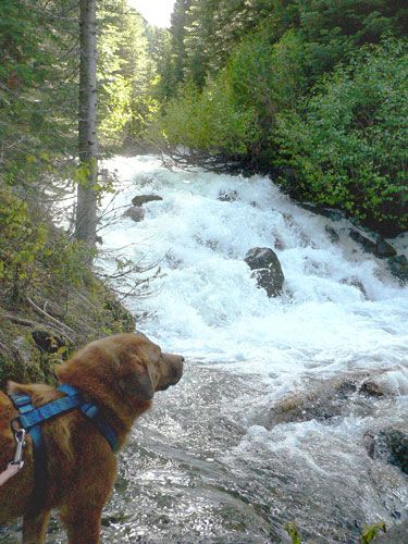
- The trail along Maxwell Creek ends at Maxwell Lake, a short hike from Shady Campground on the Lostine River. Theres a leash law in the wilderness, so be sure your dogs are tethered. KATY NESBITT / The Observer
andbull; What: Lostine is just more than two hours from Baker City, one hour and 20 minutes from La Grande and 17 minutes from Enterprise. There are many lodging options nearby in Wallowa County.
Trending
The Lostine Canyon is a wonder year round, but only accessible by skis or snowshoes from Pole Bridge, eight miles from the town of Lostine, from when the snow flies until late spring.
This year the road was open and the fallen trees and debris were cleared early in May. By now, the entire 17 miles are open to the end of the road at the Two Pan trailhead.
The trails into the Eagle Cap Wilderness are popular for backpackers and horse and mule packers, but there are several good short hikes as well.
Trending
For the casual day trip, start off with a cup of coffee at the Blue Banana in Lostine or last minute supplies at the M. Crow and Company General Store, a family-run gem run by the Crow family since 1907.
You can get fishing tackle, hardware supplies and a smattering of groceries besides the typical pop, beer and ice.
Drive up the Lostine Canyon Road as it veers of Highway 82. The road meanders through farm and ranch land for the first six miles. Look closely and you may see elk, whitetail or mule deer in the pastures of the valley.
Just before you hit Six Mile Bridge there is an Oregon Department of Fish and Wildlife area open to the public. Be sure to close the gate behind you.
From there you can wander around to pick mushrooms, bird watch, snap shots of wildflowers or hike along an old road on the face of Sheep Ridge. It’s an easy hike and provides good views of the valley.
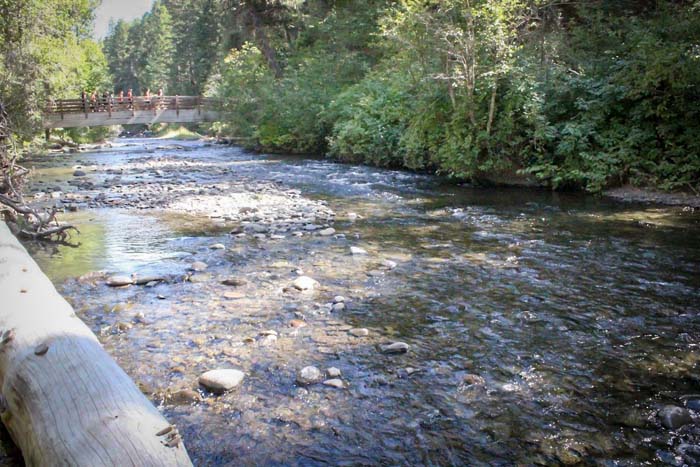
Upstream about 2.5 more miles is the Pole Bridge Picnic Area with a view of falls and the crystal clear water of the Lostine River. Standing on top of Pole Bridge is a good spot to take pictures of the tumbling water below.
As you drive up the road from Pole Bridge, there are a few curves with some pretty severe washboards, so take it easy driving up and down and provide room for oncoming traffic. The road sees a lot of use from pick-ups hauling horse trailers.
Two miles from Pole Bridge be sure to pull over to read the Wallowa-Whitman National Forest interpretive sign describing the canyon and the wilderness access.
Next stop is Williamson Campground. Depending on the time of year this is a great fishing spot, and, for the brave, there are several good holes deep enough to dive into. The beaches at Williamson are inviting to the day dreamer.
When the water is low enough, wade across the river and follow it upstream for even more sandy beaches and swimming holes. In late August, you can see spawning chinook salmon.
A mile from Williamson, just before the Lostine guard station, is a tiny trail that provides good fishing access. Keep a sharp eye out for it to the right of the road.
Walla Walla Campground is a mile up from the guard station and is another good spot to wander, fish or bask in the sun.
Maxwell Lake, accessed from trailhead 1674 at Shady Campground, is 16 miles up the canyon. The trail to Maxwell Lake is only a couple miles and is a perfect picnic spot.
Chimney Lake is a moderate day hike, approximately five miles up from the Francis-Bowman Lake Trailhead. There is still snow in patches, but the lake is fairly accessible even this early due to a mild winter.
If you are hungry when you return to Lostine, grab a burger at the Lostine Tavern, big enough to fill up the hungriest day hiker.
Lostine is 10 miles from Enterprise, 16 miles from Joseph, and 55 miles from La Grande on Highway 82, also known as the Hells Canyon Scenic Byway.
Marketplace


-
eEdition

-

-
