Out and About: Thankful for thoughtful snowplow drivers
Published 5:30 am Sunday, February 2, 2025

- Jacoby
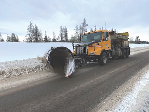
Snowplow drivers’ chief task is to ensure travelers can go, but sometimes I appreciate even more the ability to stop.
Trending
To park, in particular.
And to park in a place from which I have a reasonable chance to get out of when I’m ready to leave.
The problem with snow, of course, that it has to go somewhere.
Trending
Plows scrape the stuff off the road, but obviously it’s impractical, and inefficient, to haul tons of snow any great distance.
Hence the banks, or berms, of snow that line the road shoulders.
In the mountains (and not a few of the valleys) of Northeastern Oregon, these obstacles can be formidable indeed.
The banks in especially snowy locales, such as the Tollgate Highway, the road to Anthony Lakes Mountain Resort, and many highway passes, can tower above most vehicles.
Parking is impossible.
Snowplow drivers, though, tend to be a generous lot, in my experience.
I have many times found a thoughtful driver had pushed snow far enough off a road to make space for a couple rigs to safely get out of traffic.
This is no minor concession on roads where looming berms leave scarcely enough room for two vehicles, going in the opposite directions, to pass without an expensive exchange of paint and metal.
I appreciate the plow drivers’ efforts because they make possible snowshoeing routes (or cross-country skiing) that would otherwise be impractical at best.
One of my favorite winter drives is the Sumpter-Granite Highway.
The paved, two-lane route runs for about 15 miles between those two historic gold-mining towns west of Baker City.
Sumpter, population 200, is in Baker County, about 28 miles west of Baker City.
Granite, population about 33, is in Grant County.
The highway is a classic mountain pike, with steep grades and several dozen curves, some posted with speeds as low as 15 mph.
The highway crests at Blue Springs Summit, elevation 5,834. This modest pass marks the boundary between Baker and Grant counties as well as the divide between the North Fork John Day River system to the northwest (Granite side) and the Powder River to the southeast.
This is big snow country.
The divide is one of the first significant topographic ramparts that moisture-laden Pacific storms blast as they move east.
I suspect the nearby Greenhorn Mountains create a minor rain (and snow) shadow, but the area still gets several feet of snow most winters.
On Sunday, Jan. 5, after 10 days of successive storms that boosted the snowpack to record levels, my wife, Lisa, and I drove toward Granite. We were planning to make snowshoe tracks in the fresh powder.
After passing the summit we descended to the Gold Center Meadow. I hoped to park at one of several Forest Service roads that branch off the highway.
But as we drove it became clear that this wasn’t a feasible option.
With snow still falling, plows were focusing on the road, not on clearing possible parking spots.
Lacking choices, we ended up at the one official sno-park, at the summit.
Three weeks later, on Jan. 26, we went back.
It was a bluebird day, with only a smattering of cirrus clouds and the temperature in the upper teens.
Plow drivers had taken advantage of 20 days of dry weather, and as we ascended toward the summit I noticed they had plowed several parking spots.
I was optimistic there also would be space where the Corrigal Springs Road branches off the highway, crossing Bull Run Creek about 5 miles from Granite.
I was not disappointed.
There was space for at least three or four rigs to park. We were the only one.
Snowshoeing conditions were close to ideal.
The temperature was low enough to stave off the excessive sweating that distinguishes snowshoeing — at least on a road, like Corrigal Springs, that climbs steadily.
After the extended dry stretch the snow had consolidated and our shoes sunk in just a few inches.
Yet the consistently cool weather had prevented the freeze-and-thaw cycles that can crown the snow with an icy crust, turning an otherwise tranquil pastime into an annoying cacophony as the plastic shoes clatter on the ice.
We hiked the road, which heads generally west, for a mile or so.
The snow was about 4 feet deep. The road was marked only by the tracks of animals, primarily snowshoe hare.
For a quarter mile or so we also followed a single line of tracks that meandered on the road with occasional detours up the cutbank into the mixed conifer forest.
I suspect the culprit was either a coyote or a fox. The tracks, in powdery snow, lacked detail.
(And I lack the knowledge to distinguish between the two species.)
As always I wished I had more energy, or that midwinter days were longer.
The Corrigal Springs Road continues west for another couple miles, crossing a ridge and dropping into Beaver Meadows. If you had a way to shuttle a car to the Clear Creek Road west of Granite it would be possible to make a loop trip, following the Beaver Meadows Road to Clear Creek.
The Sumpter-Granite Highway runs for about 15 miles between the two historic gold-mining towns.
The highway, which is part of the Elkhorn Drive Scenic Byway, Forest Road 73, isn’t plowed beyond Granite. That is a popular snowmobiling route.
Marketplace


-
eEdition

-

-
