Fires prompt two area closures in Eagle Cap Wilderness
Published 9:17 am Wednesday, September 7, 2022
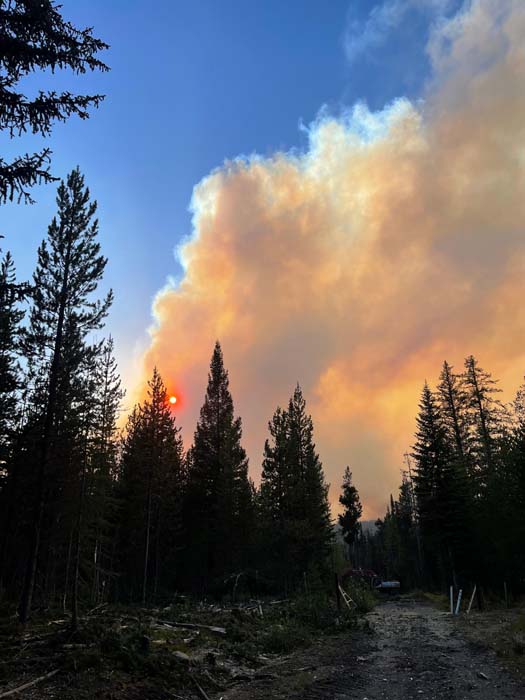
- Smoke rises from the Double Creek Fire as a masticator works on Sunday, Sept. 4, 2022.
ENTERPRISE — The Wallowa-Whitman National Forest has temporarily closed two swaths of the Eagle Cap Wilderness, including sections of several trails, as two lightning-sparked fires continue to burn.
Trending
Wallowa County Sheriff Joel Fish also expanded pre-evacuation notices on Tuesday, Sept. 6, including along the Lostine River Road south of Lostine.
The notice was Level 1 (be ready to leave) from Highway 82 at Lostine south to Fir Road, and Level 2 (get set to leave) from Fir Road south to Two Pan Campground. The Lostine River Road was closed from Moffit’s to the south.
There were no Level 3 (leave now) notices in effect in the Lostine River area.
Trending
The Level 1 and Level 2 notices were prompted by growth in the larger of the wilderness blazes, Sturgill, which is burning on the east side of the Minam River in the northwest part of the Eagle Caps.
The fire, which grew by about 2,700 acres on Sept. 6, producing a smoke plume that generated a pyrocumulus thunderhead, was estimated at just under 17,000 acres on Sept. 7.
Light rain fell on the fire early Sept. 7, said Todd Pederson, an assistant fire manager with the Wallowa-Whitman.
The Nebo Fire, meanwhile, is burning at the east end of the wilderness in the Lick Creek and Big Sheep Creek areas, north of the Imnaha River. The Nebo Fire has burned outside the wilderness near the Tenderfoot trailhead along Road 100, west of the Wallowa Mountain Loop Road (Forest Service Road 39), Pederson said.
The Nebo Fire is estimated at 9,553 acres, after growing by about 1,400 acres on Sept. 6, when it spread across Big Sheep Creek and over the top of Wing Ridge.
Under a policy in place on the Wallowa-Whitman for about 30 years, firefighters are not employing a “full suppression” strategy for the Sturgill and Nebo fires, as well as the much smaller Goat Mountain Fire, estimated at 179 acres, which is northwest of the Sturgill Fire. There was minimal activity on the Goat Mountain fire Sept. 5 and Sept. 6. Fire officials expect the Sturgill Fire will merge with the Goat Mountain Fire.
On all the wilderness fires, crews are monitoring the blazes and taking steps, such as calling in helicopters to drop water, to confine the flames to certain areas.
Firefighters on the ground are working to protect private property, including Red’s Horse Ranch and the Minam Lodge west of the Sturgill Fire, and the Lick Creek Campground near the Nebo Fire.
There are no evacuation orders for the Nebo Fire.
Closure areas
The Sturgill Fire closure includes much of the northwest part of the wilderness, from the Mount Moriah area south to beyond Mule Peak Lookout, and extending east across the Minam River Canyon to the Lostine River. The closure doesn’t include the Lake Basin.
The Nebo Fire closure covers the area southeast of Wallowa Lake, including Aneroid Mountain.
Fire official generally pleased with effects
Pederson, who has been monitoring the Sturgill and Nebo fires since they started, said he watched with trepidation on Sept. 3 as the Sturgill Fire, propelled by gusty winds in the wake of a cold front, produced a towering smoke plume.
But Pederson said when he flew over the fire later, he was “pleasantly surprised” at the aftermath.
Although the fire burned intensely in areas dominated by subalpine firs, running through the trees’ crowns, on lower slopes, dominated by ponderosa pines and Douglas-firs, the fire mainly stayed on the ground, reducing the fuel loading but killing relatively few of the trees.
“Tree mortality was surprisingly low,” Pederson said.
Fire officials said both the Sturgill and Nebo fires had potential to continue to grow significantly on Sept. 7, as hot, dry weather persisted, along with strong winds as a cold front moved through.
On Sept. 5, Oregon Gov. Kate Brown invoked the state’s Conflagration Act for the Sturgill Fire, which made available additional firefighters to help with that blaze.
Four groups of firefighters from the Oregon State Fire Marshal’s Office were assigned to protect properties, if necessary, along the Lostine River Road.
Pederson said the objective is to keep the fire from spreading into the Lostine River corridor and moving north outside the wilderness. He said the fire is about a mile and a half from the wilderness boundary, in the Goat Mountain area.
On Sept. 6 firefighters worked to build a shaded fuel break — an area where trees and other fuels are removed — along the Lostine River corridor and between Lostine and Bear Creek.
With the Nebo Fire, the goal is to prevent it from spreading farther outside the wilderness and to keep it west of the 39 Road, Pederson said.
Firefighters worked Sept. 6 to reduce fuels along that road and the 200 Road, using a machine called a masticator that chops up roadside trees and brush.
Fire crews are also working to protect structures at Lick Creek Campground and the Forest Service warming huts used during ski season.
Double Creek Fire
The biggest blaze burning in Wallowa County — and in all of Oregon — the Double Creek Fire, started by lightning on Aug. 30 northeast of Joseph, was estimated at 59,510 acres on Sept. 7.
Firefighters and crews from the Oregon State Fire Marshal’s Office installed sprinklers to protect homes in the Imnaha River area, where evacuation orders, including for the town of Imnaha, are in place.
Fire crews are striving to keep the blaze east of the Imnaha River Road. They also are using back-burning — intentionally lighting fires to get rid of fuel near containment lines — to protect the town of Imnaha, which is under a Level 3 mandatory evacuation.
Firefighters are also employing back-burning to protect structures near the Imnaha River on the south side of the fire.
JOSEPH — Oregon Highway 350 — Little Sheep Creek Highway — in Wallowa County is closed between milepost 6, 6 miles east of Joseph, and milepost 29, where the highway ends.
The Oregon Department of Transportation said that fire crews are battling the Double Creek Fire in the area that has resulted in some evacuations.
Local traffic will be allowed, but residents should check with Oregon State Police for evacuation details.
Marketplace


-
eEdition

-

-
